| Saaraltroff | |
 | |
| Verwàltung | |
|---|---|
| Land | |
| Region | |
| Département | Moselle (57) |
| Arrondissement | Sarrebourg-Château-Salins |
| Kànton | Sarrebourg |
| Kommünàlverbànd | Sarrebourg Moselle Sud |
| Àmtliga Nàma | Sarraltroff |
| Maire | Francis Mathis (2014-2020)[1] |
| Code Insee | 57629 |
| Poschtlaitzàhl | 57400 |
| Iiwohner | |
| Iiwohner | 786 |
| Flech | 11,97 km2 |
| Bevelkerungsdicht | 65,66 Iiw./km2 |
| Làg | |
| Koordinate | 48° 46′ 26″ N, 7° 03′ 46″ E / 48.773888888889°N,7.0627777777778°EKoordinate: 48° 46′ 26″ N, 7° 03′ 46″ E / 48.773888888889°N,7.0627777777778°E |
| Heche | 264 m |
 Saaraltroff Saaraltroff (Frànkrich) | |
| Website | |
| http://www.sarraltroff.fr | |
| Dialäkt: Elsassisch |
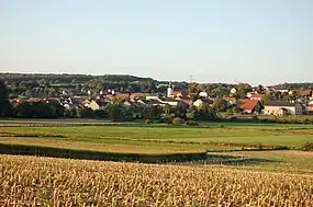
Saaraltroff (lothrìngisch; frànzeesch Sarraltroff, ditsch Saaraltdorf) ìsch e frànzeesche Gmein ìm Département Moselle ìn dr Region Grand Est (bìs 2015 Region Lothrìnge).
D Gmein ghert zem Kanton Sarrebourg un zem Arrondissement Sarrebourg-Château-Salins.
Geogràfi
Saaraltroff lijt àn dr Sààr, rund fìmf Kilometer nerdlich vun Sarrebourg uf re Heche zwìsche 235 un 326 m ìwer em Meeresspiejel.
Gschìcht
Ìm Johr 1766 ìsch d Gmein züe Frànkrich kumme. Vun 1871 bìs 1918 hàt sa zem ditsche Richslànd Elsàss-Lothringe ghert.
Verwàltung
Dr Maire vun Saaraltroff ìsch dr Francis Mathis. Saaraltroff ghert zem Kommünàlverbànd Sarrebourg Moselle Sud.
Bevelkerungsentwìcklung
| Johr | 1968 | 1975 | 1982 | 1990 | 1999 | 2008 |
| Inwohner[2] | 602 | 713 | 752 | 799 | 794 | 776 |
Dialekt
Dr lothrìngisch Dialekt vun Saaraltroff ghert zem Rhinfrankisch.
Böiwark
- Kìrich Saint-Michel (1772)
Weblink
Referanza
- ↑ Liste des maires au 25 avril 2014 (data.gouv.fr)
- ↑ INSEE: Population et logements par commune depuis le recensement de 1962 (1961 pour les Dom) à 1999
This article is issued from Wikipedia. The text is licensed under Creative Commons - Attribution - Sharealike. Additional terms may apply for the media files.