| Plounévézel | |
 | |
| Verwàltung | |
|---|---|
| Land | |
| Region | |
| Département | Finistère (29) |
| Arrondissement | Châteaulin |
| Kànton | Carhaix-Plouguer |
| Kommünàlverbànd | Poher Communauté |
| Àmtliga Nàma | Plounévézel |
| Maire | Stéphane Cotty (2014-2020)[1] |
| Code Insee | 29205 |
| Poschtlaitzàhl | 29270 |
| Iiwohner | |
| Iiwohner | 1.163 |
| Flech | 24,42 km2 |
| Bevelkerungsdicht | 50,08 Iiw./km2 |
| Làg | |
| Koordinate | 48° 17′ 56″ N, 3° 35′ 23″ W / 48.298888888889°N,3.5897222222222°WKoordinate: 48° 17′ 56″ N, 3° 35′ 23″ W / 48.298888888889°N,3.5897222222222°W |
| Heche | 119 m |
 Plounévézel Plounévézel (Frànkrich) | |
Plounévézel (bretonisch Plonevell) isch e franzesischi Gmai im Département Finistère in dr Region Bretagne.
D Gmai ghert zum Kanton Carhaix-Plouguer un zum Arrondissement Châteaulin.
Geografi
Plounévézel lyt 51 km vu Quimper un 67 km vu Brest uf ere Hechi zwische 75 m un 181 m iber Normalnull.
Gschicht
Plounévézel isch zum erschte Mol gnännt wore im 14. Jh. as Ploeneguezell (1516 Ploenevern, 1536 Ploenevezel, 1591 Plonevezel, Plouvenenzel, 1646 Prounezvel).
Verwaltig
Dr Maire vu Plounévézel isch dr Stéphane Cotty. Plounévézel ghert zum Kommunalverband Poher Communauté.
Bevelkerigsentwicklig
| Johr | 1962 | 1968 | 1975 | 1982 | 1990 | 1999 | 2008 |
| Inwohner | 760 | 658 | 714 | 829 | 1.017 | 1.015 | 1.122 |
Dialekt
Dr traditionäll Dialäkt vu Plounévézel ghert zem Bretonisch.
Kultur un Böuwärch
- Kapäll Sainte-Catherine (1616)
- Pont gaulois de Sainte-Catherine (Brugg us em 3./7. Jh.)
Bilder

Kapäll Sainte-Catherine 
Fontaine Sainte-Catherine 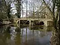
Pont gaulois de Sainte-Catherine
Weblink
Fueßnote
- ↑ Liste des maires au 25 avril 2014 (data.gouv.fr)
This article is issued from Wikipedia. The text is licensed under Creative Commons - Attribution - Sharealike. Additional terms may apply for the media files.