| Plougonvelin | |
 | |
| Verwàltung | |
|---|---|
| Land | |
| Region | |
| Département | Finistère (29) |
| Arrondissement | Brest |
| Kànton | Saint-Renan |
| Kommünàlverbànd | Pays d’Iroise |
| Àmtliga Nàma | Plougonvelin |
| Maire | Bernard Gouerec (2014-2020)[1] |
| Code Insee | 29190 |
| Poschtlaitzàhl | 29217 |
| Iiwohner | |
| Iiwohner | 4.410 |
| Flech | 18,69 km2 |
| Bevelkerungsdicht | 197,59 Iiw./km2 |
| Làg | |
| Koordinate | 48° 20′ 34″ N, 4° 42′ 41″ W / 48.342777777778°N,4.7113888888889°WKoordinate: 48° 20′ 34″ N, 4° 42′ 41″ W / 48.342777777778°N,4.7113888888889°W |
| Heche | 32 m |
 Plougonvelin Plougonvelin (Frànkrich) | |
| Website | |
| http://www.plougonvelin.fr | |
Plougonvelin (bretonisch Plougonvelen) isch e franzesischi Gmai im Département Finistère in dr Region Bretagne.
D Gmai ghert zum Kanton Saint-Renan un zum Arrondissement Brest.
Geografi
Plougonvelin lyt an dr Bucht vu Brest (Rade de Brest) am Atlantik, 18 km vu Brest un 59 km vu Quimper uf ere Hechi zwische 0 m un 88 m iber Normalnull.
Gschicht
Plougonvelin isch zum erschte Mol gnännt wore um 1330 as Ploeconvelen (1369 Plebs Comelen, 1390 Plogonelen, 1407 Ploecovelen, 1432 Ploegonvelen en Archreleon, 1516 Ploegonvelen, 1544 Ploueconvelen).
Verwaltig
Dr Maire vu Plougonvelin isch dr Bernard Gouerec. Plougonvelin ghert zum Kommunalverband Pays d’Iroise.
Bevelkerigsentwicklig
| Johr | 1962 | 1968 | 1975 | 1982 | 1990 | 1999 | 2008 |
| Inwohner | 1.439 | 1.442 | 1.567 | 1.738 | 2.167 | 2.868 | 3.625 |
Dialekt
Dr traditionäll Dialäkt vu Plougonvelin ghert zem Bretonisch.
Kultur un Böuwärch
- Abtei Saint-Mathieu de Fine-Terre (12. Jh.)
- Fort de Bertheaume (17. Jh.)
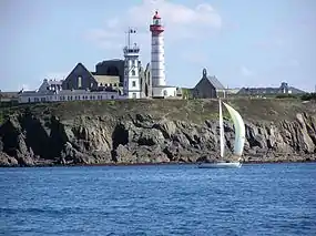
- Lychtdurm, Pointe Saint-Mathieu
Bilder
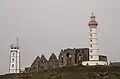
Abtei Saint-Mathieu de Fine-Terre mit Lychtdurm 
Fort de Bertheaume
Weblink
Fueßnote
- ↑ Liste des maires au 25 avril 2014 (data.gouv.fr)
This article is issued from Wikipedia. The text is licensed under Creative Commons - Attribution - Sharealike. Additional terms may apply for the media files.