| Plomodiern | |
 | |
| Verwàltung | |
|---|---|
| Land | |
| Region | |
| Département | Finistère (29) |
| Arrondissement | Châteaulin |
| Kànton | Crozon |
| Kommünàlverbànd | Pleyben-Châteaulin-Porzay |
| Àmtliga Nàma | Plomodiern |
| Maire | Joël Blaize (2014-2020)[1] |
| Code Insee | 29172 |
| Poschtlaitzàhl | 29550 |
| Iiwohner | |
| Iiwohner | 2.251 |
| Flech | 46,74 km2 |
| Bevelkerungsdicht | 46,68 Iiw./km2 |
| Làg | |
| Koordinate | 48° 10′ 52″ N, 4° 13′ 54″ W / 48.181111111111°N,4.2316666666667°WKoordinate: 48° 10′ 52″ N, 4° 13′ 54″ W / 48.181111111111°N,4.2316666666667°W |
| Heche | 94 m |
 Plomodiern Plomodiern (Frànkrich) | |
| Website | |
| https://www.plomodiern.bzh | |
Plomodiern (bretonisch Ploudiern) isch e franzesischi Gmai im Département Finistère in dr Region Bretagne.
D Gmai ghert zum Kanton Crozon un zum Arrondissement Châteaulin.
Geografi
Plomodiern lyt an dr Bucht vu Douarnenez am Atlantik in dr Region Cornouaille am Rand vum Regionale Naturpark Armorique (Parc naturel régional d'Armorique), 23 km vu Quimper un 30 km vu Brest uf ere Hechi zwische 0 m un 249 m iber Normalnull.
Gschicht
Plomodiern isch zum erschte Mol gnännt wore im 9. Jh. as Ploemadiern (1223 Ploemadiern, 1368 Ploemodiern, 1395 Ploemadiern, 1410 Ploemodiern, 1516 Ploemodiern, 1536 Ploemodiern).
Verwaltig
Dr Maire vu Plomodiern isch dr Joël Blaize. Plomodiern ghert zum Kommunalverband Pleyben-Châteaulin-Porzay.
Bevelkerigsentwicklig
| Johr | 1962 | 1968 | 1975 | 1982 | 1990 | 1999 | 2008 |
| Inwohner | 2.283 | 2.099 | 1.922 | 1.963 | 1.912 | 2.076 | 2.162 |
Dialekt
Dr traditionäll Dialäkt vu Plomodiern ghert zem Bretonisch.
Kultur un Böuwärch
- Chilche Saint-Mahouarn
- Kapäll Sainte-Marie-du-Ménez-Hom
- Kapäll Saint Corentin
Bilder
_Chapelle_Sainte-Marie-du-M%C3%A9nez-Hom_Ext%C3%A9rieur_14.JPG.webp)
Kapäll Sainte-Marie-du-Ménez-Hom 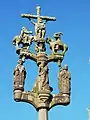
Calvaire
Weblink
Fueßnote
- ↑ Liste des maires au 25 avril 2014 (data.gouv.fr)