| La Punt Chamues-ch | |
|---|---|
 Wappe vo La Punt Chamues-ch | |
| Basisdate | |
| Staat: | Schwiiz |
| Kanton: | Graubünde (GR) |
| Region: | Maloja |
| BFS-Nr.: | 3785 |
| Poschtleitzahl: | 7522 |
| Koordinate: | 790640 / 161436 |
| Höchi: | 1'687 m ü. M. |
| Flächi: | 63.27 km² |
| Iiwohner: | 698 (31. Dezämber 2022)[1] |
| Website: | www.lapunt.ch |
 La Punt La Punt | |
| Charte | |
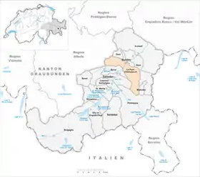
 Charte vo La Punt Chamues-ch | |
La Punt Chamues-ch (soo amtlich sit em 1. Oktober 2020, aber au scho vorane hüüffig esoo) oder früener offiziell La Punt-Chamues-ch, , italienisch und bis 1943 offiziell Ponte-Campovasto, isch e Gmaind vom Kanton Graubünde.
Geografy
D Gmaind lyt i dr Region Maloja. Si lyt zwüschet Bever und Madulain.
Vo La Punt uus gaat d Bärgstraass über de Albulapass uf Bergün.
Spraach
Z La Punt redt no fasch d Helfti vo de Lüüt Rätoromanisch.
Literatur
- Diego Giovanoli, Constant Wieser: La Punt-Chamues-ch. Siedlung und Bauten. Chur 1990, zwöiti Uuflaag 2007.
- Constant Wieser: Punt-Chamues-ch, La. In: Historisches Lexikon vo dr Schwiiz.
Weblink
Fuessnoote
- ↑ Ständige Wohnbevölkerung nach Staatsangehörigkeitskategorie, Geschlecht und Gemeinde, definitive Jahresergebnisse, 2022. Bei späteren Gemeindefusionen Einwohnerzahlen aufgrund Stand 2022 zusammengefasst. Abruf am 5. September 2023
This article is issued from Wikipedia. The text is licensed under Creative Commons - Attribution - Sharealike. Additional terms may apply for the media files.