| Collorec | |
 | |
| Verwàltung | |
|---|---|
| Land | |
| Region | |
| Département | Finistère (29) |
| Arrondissement | Châteaulin |
| Kànton | Carhaix-Plouguer |
| Kommünàlverbànd | Haute Cornouaille |
| Àmtliga Nàma | Collorec |
| Maire | Georges Croguennec (2014-2020)[1] |
| Code Insee | 29036 |
| Poschtlaitzàhl | 29530 |
| Iiwohner | |
| Iiwohner | 597 |
| Flech | 28,39 km2 |
| Bevelkerungsdicht | 23,46 Iiw./km2 |
| Làg | |
| Koordinate | 48° 17′ 11″ N, 3° 46′ 30″ W / 48.286388888889°N,3.775°WKoordinate: 48° 17′ 11″ N, 3° 46′ 30″ W / 48.286388888889°N,3.775°W |
| Heche | 141 m |
 Collorec Collorec (Frànkrich) | |
Collorec (bretonisch Koloreg) isch e franzesischi Gmai im Département Finistère in dr Region Bretagne.
D Gmai ghert zum Kanton Carhaix-Plouguer un zum Arrondissement Châteaulin.
Geografi
Collorec lyt 41 km vu Quimper un 54 km vu Brest uf ere Hechi zwische 72 m un 221 m iber Normalnull.
Gschicht
Collorec isch zum erschte Mol gnännt wore anne 1108 as Choloroc (1536 Collorec).
Verwaltig
Dr Maire vu Collorec isch dr Georges Croguennec. Collorec ghert zum Kommunalverband Haute Cornouaille.
Bevelkerigsentwicklig
| Johr | 1962 | 1968 | 1975 | 1982 | 1990 | 1999 | 2008 |
| Inwohner | 1.148 | 1.038 | 891 | 778 | 692 | 647 | 667 |
Dialekt
Dr traditionäll Dialäkt vu Collorec ghert zem Bretonisch.
Böuwärch
- Chilche Notre-Dame
- Kapäll Sainte-Marguerite
Bilder

Chilche Notre-Dame 
Kapäll Sainte-Marguerite 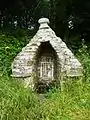
Oratoire Sainte-Barbe 
Dotedänkmol
Weblink
Fueßnote
- ↑ Liste des maires au 25 avril 2014 (data.gouv.fr)
This article is issued from Wikipedia. The text is licensed under Creative Commons - Attribution - Sharealike. Additional terms may apply for the media files.