| Brennilis | |
 Réservoir Saint-Michel | |
| Verwàltung | |
|---|---|
| Land | |
| Region | |
| Département | Finistère (29) |
| Arrondissement | Châteaulin |
| Kànton | Carhaix-Plouguer |
| Kommünàlverbànd | Monts d’Arrée Communauté |
| Àmtliga Nàma | Brennilis |
| Maire | Alexis Manach (2014-2020)[1] |
| Code Insee | 29018 |
| Poschtlaitzàhl | 29690 |
| Iiwohner | |
| Iiwohner | 440 |
| Flech | 18,69 km2 |
| Bevelkerungsdicht | 24,08 Iiw./km2 |
| Làg | |
| Koordinate | 48° 21′ 27″ N, 3° 51′ 05″ W / 48.3575°N,3.8513888888889°WKoordinate: 48° 21′ 27″ N, 3° 51′ 05″ W / 48.3575°N,3.8513888888889°W |
| Heche | 255 m |
 Brennilis Brennilis (Frànkrich) | |
| Website | |
| http://www.brennilis.com, http://www.mairie-brennilis.com | |
Brennilis (bretonisch Breniliz) isch e franzesischi Gmai im Département Finistère in dr Region Bretagne.
D Gmai ghert zum Kanton Carhaix-Plouguer un zum Arrondissement Châteaulin.
Geografi
Brennilis lyt im Regionale Naturpark Armorique (Parc naturel régional d'Armorique), an dr Uuslaifer vu dr Monts d'Arrée, 45 km vu Quimper un 47 km vu Brest uf ere Hechi zwische 149 m un 278 m iber Normalnull.
Gschicht
Brennilis isch zum erschte Mol gnännt wore anne 1653 as Brennilis. Es het dört mol für chürzeri Ziit es Kärnkraftwärk geh.
Verwaltig
Dr Maire vu Brennilis isch dr Alexis Manach. Brennilis ghert zum Kommunalverband Monts d’Arrée Communauté.
Bevelkerigsentwicklig
| Johr | 1962 | 1968 | 1975 | 1982 | 1990 | 1999 | 2008 |
| Inwohner | 615 | 760 | 654 | 573 | 439 | 467 | 435 |
Dialekt
Dr traditionäll Dialäkt vu Brennilis ghert zem Bretonisch.
Kultur un Böuwärch
- Chilche Notre-Dame
- Calvaire de Nestavel
- Alignement de Leïtan
- Dolmen de Ty-ar-Boudiged
Bilder

Chilche Notre-Dame 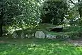
Dolmen de Ty-ar-Boudiged 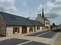
Rue principale
Weblink
Fueßnote
- ↑ Liste des maires au 25 avril 2014 (data.gouv.fr)
This article is issued from Wikipedia. The text is licensed under Creative Commons - Attribution - Sharealike. Additional terms may apply for the media files.