| Billiers | |
 Le Domaine de Rochevilaine | |
| Verwàltung | |
|---|---|
| Land | |
| Region | |
| Département | Morbihan (56) |
| Arrondissement | Vannes |
| Kànton | Muzillac |
| Kommünàlverbànd | Arc Sud Bretagne |
| Àmtliga Nàma | Billiers |
| Maire | Régine Rosset (2014-2020)[1] |
| Code Insee | 56018 |
| Poschtlaitzàhl | 56190 |
| Iiwohner | |
| Iiwohner | 1.047 |
| Flech | 5,87 km2 |
| Bevelkerungsdicht | 154,86 Iiw./km2 |
| Làg | |
| Koordinate | 47° 31′ 54″ N, 2° 29′ 22″ W / 47.531666666667°N,2.4894444444444°WKoordinate: 47° 31′ 54″ N, 2° 29′ 22″ W / 47.531666666667°N,2.4894444444444°W |
| Heche | 20 m |
 Billiers Billiers (Frànkrich) | |
| Website | |
| http://www.billiers.fr | |
Billiers (bretonisch Beler) isch e franzesischi Gmai im Département Morbihan in dr Region Bretagne.
D Gmai ghert zum Kanton Muzillac un zum Arrondissement Vannes.
Geografi
Billiers lyt am Atlantik, 25 km vu Vannes un 70 km vu Lorient uf ere Hechi zwische 0 m un 29 m iber Normalnull.
Gschicht
Billiers isch zum erschte Mol gnännt wore anne 1250 as Beler (1367: Beleiers, 1427: Bellié, 1441: Biller, 1516: Boller, 1630: Belhel).
Verwaltig
D Maire vu Billiers isch d Régine Rosset. Billiers ghert zum Kommunalverband Arc Sud Bretagne.
Bevelkerigsentwicklig
| Johr | 1962 | 1968 | 1975 | 1982 | 1990 | 1999 | 2008 |
| Yywohner | 650 | 714 | 804 | 781 | 760 | 705 | 922 |
Dialekt
Dr traditionell Dialäkt vu Billiers ghert zum Gallo.
Kultur un Böuwärch
- Cairn Grays
- Dolmen Crapaud, Goëren
- Abbaye Notre-Dame de Prières (grindet anne 1252 vum Jean I. de Bretagne)
- Église Saint-Maxent (17. Jh.)
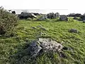
Cairn Grays 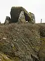
Dolmen Crapaud
Weblink
- http://www.billiers.fr
- Billiers uf geobreizh.com (Internet-Archive)
Fueßnote
- ↑ Liste des maires au 25 avril 2014 (data.gouv.fr)
This article is issued from Wikipedia. The text is licensed under Creative Commons - Attribution - Sharealike. Additional terms may apply for the media files.