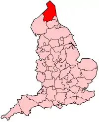


Northumberland of Noardhumberlân in it noardlikste greefskip fan Ingelân, dat oant 1 april 2009 in twatriems foarm fan bestjoer hie, mei in county council as fertsjintwurdigjend lichem fan 'e hiele county en dêrûnder noch in seistal distrikten mei elts in eigen bestjoersried. Yn 2009 binne dy distrikten lykwols opheft, en is de county council omfoarme ta in unitary authority. Northumberland leit yn de Ingelske regio Noardeast-Ingelân en hat 307.190 ynwenners. It oerflak beslacht 5013,1 km2. It haadplak is Morpeth.
Demografy
fan de befolking is 17,6% boppe de 65 jier. De wurkleazens berint 3,8% fan de beropsbefolking (sifers folkstelling 2001).
It tal ynwenners gie omheech fan likernôch 305.500 yn 1991 nei 307.190 yn 2001.
Eardere distrikten
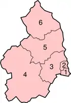
Oant 1 april 2009 bestiene yn it greefskip Northumberland fan doe de neifolgjende distrikten:
| Distrikten | Detailkaart |
|---|---|
|
 |
Foar de kust fan Northumberland lizze ek noch de Farne-eilannen (mei Lindisfarne, Holy Island).
Plakken
- Alnwick, Amble, Ashington
- Bamburgh, Bedlington, Berwick-upon-Tweed, Blyth
- Cramlington
- Haltwhistle, Hexham
- Morpeth
- Newbiggin-by-the-Sea
- Prudhoe
- Rothbury
- Seahouses
- Wooler