| Cél articllo est ècrit en arpetan supradialèctâl / ORB lârge. |
| Aoûta | |
 Viua sur la vela dês Sent-Cretôblo | |
 Hèraldica |
|
| Administracion | |
|---|---|
| Payis | |
| Province | |
| Code postâl | 11100 |
| Code ISTAT | 007003 |
| Code cadastrâl | A326 |
| Prèfixo tèl. | 0165 |
| Dèmografia | |
| Populacion | 33 104 hab. (31-8-2022[1]) |
| Densitât | 1 576 hab./km2 |
| Geografia | |
| Coordonâs | 45° 44′ 00″ bise, 7° 19′ 00″ levant |
| Hôtior | Min. 583 m Max. 583 m |
| Supèrficie | 2 100 ha = 21 km2 |
| De tota sôrta | |
| Sant patron | Sent Grât |
| Vôga | 7 de septembro |
| Localisacion | |
| Lims | |
| Seto Vouèbe | http://www.comune.aosta.it/fr/home |
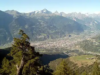
Aoûta [B.R.E.L. : Outa], tot-pariér Aoûtha, sovent la Vela [B.R.E.L. : Veulla][2], est na comena et la capitâla de la Vâl d’Aoûta.
Histouère
- Sent Grât, èvèco.
Arch·itèctura
Pèrsonalitâts
- Enrico Thiébat
- Christiane Dunoyer, antropologa
- Jules Brocherel
Notes et refèrences
- ↑ (it) []https://demo.istat.it/app/?a=2022&i=D7B sur lo seto de l’ISTAT.
- ↑ (fr) Gnalèi - Ville - patois d'Aoste
This article is issued from Wikipedia. The text is licensed under Creative Commons - Attribution - Sharealike. Additional terms may apply for the media files.

