| Vianópolis | |||
|---|---|---|---|
 | |||
| municipo de Brazilo | |||
|
| |||
| Flago | |||
| Administrado | |||
| Demografio | |||
| Loĝantaro | 14 956 (2022) [+] | ||
| Loĝdenso | 16 loĝ./km² | ||
| Geografio | |||
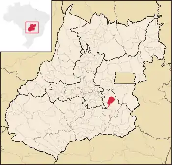
| Geografia situo | 16° 45′ S, 48° 31′ U (mapo)-16.741944444444-48.515833333333Koordinatoj: 16° 45′ S, 48° 31′ U (mapo) [+] | ||
| Alto | 985 m [+] | ||
| Areo | 954,279 km² (9 542 7.9 ha) [+] | ||
 | |||
| |||
|
| |||
| Alia projekto | |||


Vianópolis estas municipo de la brazila subŝtato Gojaso, kiu taksis 12.548 loĝantojn en 2010 [1].
Estaciodomo
Subŝtate
Vidu ankaŭ
Eksteraj ligiloj
Referencoj
- ↑ IBGE (2010). Censo 2010 (HTML). Alirita 03 de setembro 2011.
Koordinatoj: 16° 44′ 31″ S 48° 30′ 57″ U / 16.741944 °S, 48.515833 °U (mapo)
This article is issued from Wikipedia. The text is licensed under Creative Commons - Attribution - Sharealike. Additional terms may apply for the media files.