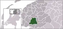
| Municipo Skarsterlân | ||
|---|---|---|
|
|
| |
| Flago de la municipo Skarsterlân | Blazono de municipo Skarsterlân | |
 | ||
| nederlanda municipo • nederlanda municipo | ||
| Provinco | Frislando | |
| Ĉefloko | Joure | |
| Areo - Tero - Akvo |
216,89 km² 186,41 km² 30,48 km² | |
| Loĝantaro - Loĝdenso |
26.992 (1-a de majo 2006) 145 loĝ./km² | |
| Geografia situo | 52° 58′ N, 5° 47′ O (mapo)52.9666666666675.7833333333333Koordinatoj: 52° 58′ N, 5° 47′ O (mapo) | |
| ||
|
| ||
| Gravaj trafikaj arterioj | A6, A7, A32, E22, N354, N924, N927 | |
| CBS-municipokodo | 0051, 0139 | |
| Telefona kodo | 0566 | |
| Poŝtkodo | 8461–8544 | |
| Oficiala retejo | http://www.skarsterlan.nl | |
![]() Skarsterlân (nederlande Scharsterland;52° 58′ N, 5° 47′ O (mapo)52.9666666666675.7833333333333
) estas municipo en la nederlanda provinco Frislando kun 26 992 loĝantoj sur areo de 216,89 km². Komunuma centro estas la loĝloko Joure (nederlande; okcidentfrise De Jouwer).
Skarsterlân (nederlande Scharsterland;52° 58′ N, 5° 47′ O (mapo)52.9666666666675.7833333333333
) estas municipo en la nederlanda provinco Frislando kun 26 992 loĝantoj sur areo de 216,89 km². Komunuma centro estas la loĝloko Joure (nederlande; okcidentfrise De Jouwer).

Satelitfoto de Skarsterlân kaj ĉirkaŭaĵo
Skarsterlân estis formita post komunuma rearanĝo en 1984 per kunfandiĝo de Doniawerstal kaj Haskerland, parto de Utingeradeel kun la vilaĝoj Akmarijp kaj Terkaple kaj la vilaĝo Nieuwebrug kiu antaŭe apartenis al la municipo Heerenveen. Ekde la 1-an da januaro 2014 ĝi apertenas al la municipo De Friese Meren.
Vilaĝoj
Nombro da loĝantoj je la 1-a de januaro 2004:
| Nederlanda nomo | Frisa nomo | Loĝantoj |
| Joure | De Jouwer | 12.810 |
| Sint Nicolaasga | Sint Nyk | 3268 |
| Oudehaske | Âldehaske | 1940 |
| Langweer | Langwar | 900 |
| Sintjohannesga | Sint Jânsgea | 860 |
| Scharsterbrug | Skarsterbrêge | 710 |
| Rottum | Rottum | 700 |
| Haskerhorne | Haskerhoarne | 490 |
| Idskenhuizen | Jiskenhuzen | 420 |
| Rotsterhaule | Rotsterhaule | 400 |
| Haskerdijken | Haskerdiken | 390 |
| Ouwsterhaule | Ousterhaule | 300 |
| Goingarijp | Goaiïngaryp | 230 |
| Rohel | Reahel | 230 |
| Terkaple | Terkaple | 210 |
| Vegelinsoord | Vegelinsoard | 210 |
| Boornzwaag | Boarnsweach | 190 |
| Tjerkgaast | Tsjerkgaast | 190 |
| Nieuwebrug | Nijbrêge | 150 |
| Broek | De Broek | 130 |
| Akmarijp | Eagmaryp | 120 |
| Ouwster-Nijega | Ousternijegea | 100 |
| Doniaga | Dunegea | 90 |
| Oldeouwer | Alde Ouwer | 80 |
| Dijken | Diken | 70 |
| Snikzwaag | Sniksweach | 60 |
| Legemeer | Legemar | 50 |
| Nijehaske | Nijehaske | 50 |
| Rotstergaast | Rotstergaast | 20 |
| Teroele | Teroele | 20 |
Fonto: CBS
Vilaĝetoj
|
|
|
|
This article is issued from Wikipedia. The text is licensed under Creative Commons - Attribution - Sharealike. Additional terms may apply for the media files.


