| Santo Antônio da Platina | |||
|---|---|---|---|
 | |||
| municipo de Brazilo | |||
|
|
| ||
| Flago | Blazono | ||
| Administrado | |||
| En TTT | Oficiala retejo [+] | ||
| Demografio | |||
| Loĝantaro | 44 369 (2022) [+] | ||
| Loĝdenso | 61 loĝ./km² | ||
| Geografio | |||
| Geografia situo | 23° 18′ S, 50° 5′ U (mapo)-23.295-50.076944444444Koordinatoj: 23° 18′ S, 50° 5′ U (mapo) [+] | ||
| Alto | 496 m [+] | ||
| Areo | 721,625 km² (7 216 2.5 ha) [+] | ||
 | |||
| |||
|
| |||
| Alia projekto | |||


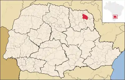
Santo Antônio da Platina estas municipo de la brazila subŝtato Paranao, kiu taksis 42.688 loĝantojn en 2010 [1].

Blazono
Subŝtate
Referencoj
- ↑ IBGE (2010). Censo 2010 (HTML). Alirita 27 de aŭgusto 2011.
Vidu ankaŭ
Eksteraj ligiloj
- portugale Oficiala paĝo Arkivigite je 2009-07-12 per la retarkivo Wayback Machine
- portugale Asocio de Municipoj de Paranao
Koordinatoj: 23° 17′ 42″ S 50° 04′ 37″ U / 23.295 °S, 50.076944 °U (mapo)
This article is issued from Wikipedia. The text is licensed under Creative Commons - Attribution - Sharealike. Additional terms may apply for the media files.