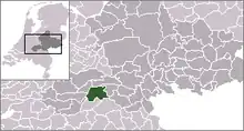
| Municipo West Maas en Waal | ||
|---|---|---|
|
|
| |
| Flago de la municipo West Maas en Waal | Blazono de municipo West Maas en Waal | |
 | ||
| nederlanda municipo | ||
| Provinco | Gelderlando | |
| Urbestro | Vincent van Neerbos | |
| Ĉefloko | Beneden-Leeuwen | |
| Areo - Tero - Akvo |
85,84 km² 81,50 km² 4,34 km² | |
| Loĝantaro - Loĝdenso |
19 581 (en 2021) 224 loĝ./km² | |
| Geografia situo | 51° 53′ N, 5° 31′ O (mapo)51.8833333333335.5166666666667Koordinatoj: 51° 53′ N, 5° 31′ O (mapo) | |
| ||
|
| ||
| Gravaj trafikaj arterioj | N322, N323 | |
| CBS-municipokodo | 0668 | |
| Poŝtkodo | 6620–6621, 6626–6629, 6657–6659 | |
| Oficiala retejo | https://www.westmaasenwaal.nl/ | |
![]() West Maas en Waal (51° 53′ N, 5° 31′ O (mapo)51.8833333333335.5166666666667
) estas municipo en la nederlanda provinco Gelderlando. Laŭ la stato de 2021 en la municipo vivis 19 581 loĝantoj sur areo de 85,15 kvadrataj kilometroj (de kiu 4,34 km² estas akvo), kio rezultigas loĝdenson de 230 loĝantoj/km².
West Maas en Waal (51° 53′ N, 5° 31′ O (mapo)51.8833333333335.5166666666667
) estas municipo en la nederlanda provinco Gelderlando. Laŭ la stato de 2021 en la municipo vivis 19 581 loĝantoj sur areo de 85,15 kvadrataj kilometroj (de kiu 4,34 km² estas akvo), kio rezultigas loĝdenson de 230 loĝantoj/km².
La teritorio havas komunan limon kun Druten, Neder-Betuwe, Maasdriel, Wijchen, Neerijnen, Tiel kaj Oss.
Partoj
Alphen, Altforst, Appeltern, Beneden-Leeuwen, Boven-Leeuwen, Dreumel, Maasbommel kaj Wamel. La municipejo situas en Beneden-Leeuwen.
| Provinco Gelderlando | |
|---|---|
| Aalten | Apeldoorn | Arnhem | Barneveld | Berg en Dal | Berkelland | Beuningen | Bronckhorst | Brummen | Buren | Culemborg | Doesburg | Doetinchem | Druten | Duiven | Ede | Elburg | Epe | Ermelo | Geldermalsen | Harderwijk | Hattem | Heerde | Heumen | Lingewaal | Lingewaard | Lochem | Maasdriel | Montferland | Neder-Betuwe | Neerijnen | Nijkerk | Nimego | Nunspeet | Oldebroek | Oost Gelre | Oude IJsselstreek | Overbetuwe | Putten | Renkum | Rheden | Rozendaal | Scherpenzeel | Tiel | Viĥeno | Voorst | Wageningen | West Maas en Waal | Westervoort | Winterswijk | Zaltbommel | Zevenaar | Zutphen | |
| Nederlando | Provincoj | Municipoj | |
This article is issued from Wikipedia. The text is licensed under Creative Commons - Attribution - Sharealike. Additional terms may apply for the media files.


