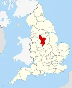
| Derbyshire | |||||
|---|---|---|---|---|---|
| Graflando | |||||
 | |||||
 |  | ||||
| Flago | Blazono | ||||
| ceremonia kantono de Anglio [+] | |||||
| |||||
| Lando | Anglio | ||||
| Koordinatoj | 53° N, 2° U (mapo)53.18-1.61Koordinatoj: 53° N, 2° U (mapo) | ||||
| Ĉefurbo | Derby | ||||
| - koordinatoj | 53° N, 2° U (mapo)53.18-1.61Koordinatoj: 53° N, 2° U (mapo) [+] | ||||
| Areo | 2 624,7888 km² (262 479 ha) [+] | ||||
| Loĝantaro | 1 056 000 [+] (2021) | ||||
| ISO 3166-2 | GB-DBY | ||||
|
|||||
|
|||||
 |
|||||
| Derbyshire | |||||
| En TTT: Oficiala retejo [+] | |||||
Derbyshire estas unu el la graflandoj de Anglio. Ĝi situas en la regiono East Midlands.
- Logantaro - 750 000
- Areo - 225 074 hektaroj
La plejmulto de la nacia parko Peak District situas en Derbyshire.
Troviĝas 13 urboj kun inter 10 000 kaj 100 000 loĝantoj kaj granda areo de maldense loĝata agrikutura tero.
75% de la loĝantaro vivas en 25% de la provinco.
La provinco ankaŭ enhavas la urbegon Derby - ĝi estas unuara instanco.
Urboj kaj vilaĝoj
- Alfreton, Alton, Ashbourne, Ashford-in-the-Water
- Bakewell, Bamford, Baslow, Beeley, Belper, Birch Vale, Bolehill, Bolsover, Borrowash, Bretby, Brimington, Burbage, Buxton
- Castleton, Chapel-en-le-Frith, Charlesworth, Chelmorton, Chesterfield, Clay Cross, Clowne,Cressbrook, Creswell, Cromford, Crowden, Curbar
- Derby, Dronfield, Duffield
- Earl Sterndale, Eckington, Edale, Edensor, Eyam
- Fernilee
- Gamesley, Glossop, Great Hucklow
- Hadfield, Hartington, Hathersage, Hayfield, Heanor
- Ilkeston
- Little Hucklow
- Marston Montgomery, Marston on Dove, Matlock, Melbourne, Miller's Dale, Morley
- New Mills, Newhaven
- Over Haddon
- Peak Forest
- Riber, Ripley
- Shipley, Shirebrook, Staveley, Stoney Middleton, Stretton, Sudbury, Swadlincote
- Tansley, Taxal, Thornhill, Tibshelf, Tideswell, Tunstead Milton
- Walton, Wardlow, Whaley Bridge, Whitwell, Wirksworth
- Youlgreave
Vizitindaĵoj
- Alfreton Hall
- Alsop Hall
- Arbor Low Stone Circle
- Barlborough Hall
- Bradbourne Hall
- Bradley Hall
- Bretby Hall
- Buxton Hall
- Buxton Museum & Art Gallery
- Calke Abbey
- Carsington Reservoir
- Chatsworth
- Coxbench Hall
- Derwent Reservoir
- Derwent Valley Mills
- Dom-muzeo de Pickford
- Ednaston Manor
- Eyam Hall
- Fenney Bentley Old Hall
- Flagg Hall
- Glossop Hall
- Great Longstone Hall
- Haddon Hall
- Hartington Hall
- Heights of Abraham
- Hob Hurst's House
- Howden Reservoir
- Ilam Hall
- Kedleston Hall
- Ladybower Reservoir
- Longdendale
- Longdendale Trail, longdistanca vojeto por piedirantoj
- Longford Hall
- Mam Tor
- Muzeo kaj artgalerio de Derby
- National Stone Centre, Wirksworth
- Nine Ladies Stone Circle
- Norbury Hall
- Parwich Hall
- Peveril Castle
- Renishaw Hall
- Riber Castle
- Speedwell Cavern
- Sudbury Hall
- Sutton Scarsdale Hall
- Thornbridge Hall
- Well dressing - antikva ceremoniejo
- Wingfield Manor
Eksteraj ligiloj
- Oficiala retejo - en la angla lingvo
| ||||||
This article is issued from Wikipedia. The text is licensed under Creative Commons - Attribution - Sharealike. Additional terms may apply for the media files.

.svg.png.webp)