| Courcelles-Ceinture | ||||
|---|---|---|---|---|
 Stacidomo Courcelles-Ceinture | ||||
| fervoja stacidomo | ||||
| Lokigo | ||||
| Lando | Francio | |||
| Urbo | Parizo | |||
| Arondismento | 17-a | |||
| Geografia situo | 48° 53′ 14″ N, 2° 18′ 4″ O (mapo)48.8872232.301118Koordinatoj: 48° 53′ 14″ N, 2° 18′ 4″ O (mapo) | |||
| ||||
| Historio | ||||
| Malfermo | 1869 | |||
| Fermo | 1934 | |||
| Administrado kaj utiligado | ||||
| Trajno-linio | Petite Ceinture | |||
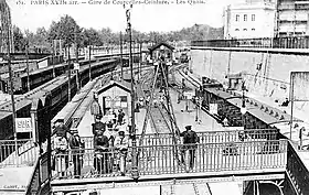
Courcelles-Ceinture estis franca stacidomo de Fervojo Petite Ceinture, situinta en la 17-a arondismento de Parizo, ĉe interkruciĝo de Stratoj Verniquet kaj Alfred-Roll, en regiono Francilio. Ĝi estis detruita en la 1950-aj jaroj.
Vidu ankaŭ
Eksteraj ligiloj
This article is issued from Wikipedia. The text is licensed under Creative Commons - Attribution - Sharealike. Additional terms may apply for the media files.
