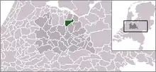
| Municipo Baarn | |||
|---|---|---|---|
|
|
| ||
| Flago de la municipo Baarn | Blazono de municipo Baarn | ||
 | |||
| nederlanda municipo | |||
| Provinco | Utreĥto | ||
| Ĉefloko | Baarn | ||
| Areo - Tero - Akvo |
33,03 km² 32,47 km² 0,46 km² | ||
| Loĝantaro - Loĝdenso |
24.443 (1-a de julio 2006) 753 loĝ./km² | ||
| Geografia situo | 52° 13′ N, 5° 18′ O (mapo)52.2166666666675.3Koordinatoj: 52° 13′ N, 5° 18′ O (mapo) | ||
| |||
| |||
|
| |||
| Gravaj trafikaj arterioj | A1, N221, N414 | ||
| CBS-municipokodo | 0308 | ||
| Telefona kodo | 035 | ||
| Poŝtkodo | 3740–3744 | ||
| Oficiala retejo | https://www.baarn.nl/ | ||
![]() Baarn (52° 13′ N, 5° 18′ O (mapo)52.2166666666675.3
)
estas municipo en la nederlanda provinco Utrecht, kiu situas ĉe la rivero Eem. La municipo havas 24 443 loĝantojn (1-a de januaro 2007, fonto: CBS) sur areo de 33,03 km² (de kiu 0,46 km² akvo).
Baarn (52° 13′ N, 5° 18′ O (mapo)52.2166666666675.3
)
estas municipo en la nederlanda provinco Utrecht, kiu situas ĉe la rivero Eem. La municipo havas 24 443 loĝantojn (1-a de januaro 2007, fonto: CBS) sur areo de 33,03 km² (de kiu 0,46 km² akvo).
Esperanto
Baarn, laŭ Enciklopedio de Esperanto, estas naskiĝloko de Johannes Hartog.
Eksteraj ligiloj
- http://www.baarn.nl
- http://www.oud-baarn.nl
- http://www.cbs.nl/nl-NL/menu/themas/milieu-natuur-ruimte/ruimte/publicaties/cartografie-geografie/geografische-data/2001-bevolkingskernen-in-nederland.htm Arkivigite je 2007-01-24 per la retarkivo Wayback Machine
- http://www.hotelpromenade.nl Arkivigite je 2021-05-09 per la retarkivo Wayback Machine
- http://www.royalbaarn.com
| Provinco Utreĥto | |
|---|---|
| Amersforto | Baarn | Bunnik | Bunschoten | De Bilt | De Ronde Venen | Eemnes | Houten | IJsselstein | Leusden | Lopik | Montfoort | Nieuwegein | Oudewater | Renswoude | Rhenen | Soest | Stichtse Vecht | Utrechtse Heuvelrug | Utreĥto | Veenendaal | Vijfheerenlanden | Wijk bij Duurstede | Woerden | Woudenberg | Zeist | |
| Nederlando | Provincoj | Municipoj | |
This article is issued from Wikipedia. The text is licensed under Creative Commons - Attribution - Sharealike. Additional terms may apply for the media files.


