Tse Bonito
Tse Bonito (Navajo: Tsé Biniiʼ Tó) ist ein Dorf im McKinley County im US-Bundesstaat New Mexico.
| Tse Bonito | |
|---|---|
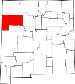
 Lage in New Mexico | |
| Basisdaten | |
| Staat: | Vereinigte Staaten |
| Bundesstaat: | New Mexico |
| County: | McKinley County |
| Koordinaten: | 35° 39′ N, 109° 2′ W |
| Zeitzone: | Mountain (UTC−7/−6) |
| Einwohner: | 380 (Stand: 2020) |
| Haushalte: | 86 (Stand: 2020) |
| Fläche: | 3,7 km² (ca. 1 mi²) davon 3,7 km² (ca. 1 mi²) Land |
| Bevölkerungsdichte: | 103 Einwohner je km² |
| Höhe: | 2080 m |
| Vorwahl: | +1 505 |
| FIPS: | 35-79885 |
| GNIS-ID: | 0897558 |
Der Ort hat 261 Einwohner auf einer Fläche von 3,7 km². Die Bevölkerungsdichte liegt bei 71,5/km². Tse Bonito liegt direkt an der Grenze zum US-Bundesstaat Arizona und zum Navajo Nation Reservation. Das Dorf wird von der New Mexico State Route 264 tangiert.
This article is issued from Wikipedia. The text is licensed under Creative Commons - Attribution - Sharealike. Additional terms may apply for the media files.
