South Fork (Antarktika)
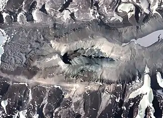
Die South Fork (englisch für Südgabel) ist das südliche der beiden Seitentäler des Wright Valley im ostantarktischen Viktorialand. Vom nördlichen Seitental North Fork wird es durch den Tafelberg Dais getrennt.
| South Fork | ||
|---|---|---|
 Die South Fork unterhalb des Dais (Bildmitte) im Wright Valley Die South Fork unterhalb des Dais (Bildmitte) im Wright Valley | ||
| Lage | Viktorialand, Ostantarktika | |
| Gebirge | Transantarktisches Gebirge | |
| Geographische Lage | 77° 34′ 0″ S, 161° 15′ 0″ O | |
| ||
Benannt wurde das Tal von Teilnehmern einer von 1958 bis 1959 dauernden Kampagne im Rahmen der neuseeländischen Victoria University’s Antarctic Expeditions.
Weblinks
- South Fork. In: Geographic Names Information System. United States Geological Survey, United States Department of the Interior, archiviert vom (englisch).
- South Fork auf geographic.org (englisch)
This article is issued from Wikipedia. The text is licensed under Creative Commons - Attribution - Sharealike. Additional terms may apply for the media files.
