Recanto das Emas
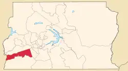
Recanto das Emas, amtlich portugiesisch Região Administrativa de Recanto das Emas, ist die Verwaltungsregion RA XV mit 160.000 Einwohnern 27 km südwestlich von Brasilia im brasilianischen Bundesdistrikt. Die Verwaltungsregion grenzt an Samambaia, Gama, Riacho Fundo II und Santo Antônio do Descoberto (GO) an. Recanto das Emas wurde am 28. Juli 1993 gegründet. Der Ortsname leitet sich von der hier häufig vorkommenden, für den Cerrado typischen Pflanze Canela de Ema (Vellozia squamata) ab.

Canela de Ema, eine in Recanto das Emas vorkommende Pflanze
| Região Administrativa de Recanto das Emas Recanto das Emas | |||
|---|---|---|---|
| |||
| Koordinaten | 15° 54′ S, 48° 4′ W | ||
 Recanto das Emas auf der Karte des Distrito Federal Recanto das Emas auf der Karte des Distrito Federal | |||
| Gründung | 29.07.1993 | ||
| Basisdaten | |||
| Staat | Brasilien | ||
| Bundesdistrikt | Distrito Federal | ||
| Verwaltungsregion | RA XV | ||
| Fläche | 101,2 km² | ||
| Einwohner | 160.000 | ||
| Dichte | 1.580,7 Ew./km² | ||
| Telefonvorwahl | (+55) 61 | ||
| Zeitzone | UTC−3 | ||
| Website | recanto.df (brasilianisches Portugiesisch) | ||
| Politik | |||
| Regionaladministrator | Sebastião Stênio Pinho | ||
Verwaltung
Administrator der Verwaltungsregion ist Sebastião Stênio Pinho.
Weblinks
Commons: Recanto das Emas (Distrito Federal) – Sammlung von Bildern, Videos und Audiodateien
- Website der Verwaltungsregion Recanto das Emas (brasilianisches Portugiesisch)
This article is issued from Wikipedia. The text is licensed under Creative Commons - Attribution - Sharealike. Additional terms may apply for the media files.
