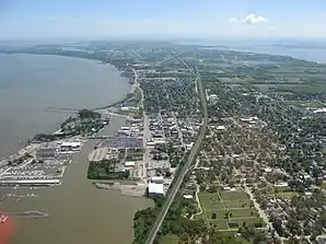
Port Clinton
Port Clinton[1] ist eine City im und der Verwaltungssitz vom Ottawa County in Ohio, Vereinigte Staaten, mit gut 6000 Einwohnern.
| Port Clinton | |
|---|---|
 | |
| Lage in Ohio | |
 | |
| Basisdaten | |
| Staat: | Vereinigte Staaten |
| Bundesstaat: | Ohio |
| County: | Ottawa County |
| Koordinaten: | 41° 31′ N, 82° 56′ W |
| Zeitzone: | Eastern (UTC−5/−4) |
| Einwohner: | 6.025 (Stand: 2020) |
| Haushalte: | 3.052 (Stand: 2020) |
| Fläche: | 5,9 km² (ca. 2 mi²) davon 5,4 km² (ca. 2 mi²) Land |
| Bevölkerungsdichte: | 1.116 Einwohner je km² |
| Höhe: | 177 m |
| Postleitzahlen: | 43446, 43452 |
| Vorwahl: | +1 419 |
| FIPS: | 39-64150 |
| GNIS-ID: | 1061564 |
| Website: | www.portclinton.com |
| Bürgermeister: | Michael Snider |
Der Ort liegt auf der Marblehead Halbinsel an der Mündung des Portage River in den Eriesee. Der örtliche Flughafen Carl R. Keller Field trägt den IATA-Code PCW.
Geographie
Port Clintons geographische Koordinaten sind 41° 31′ N, 82° 56′ W (41,509857, −82,940156).[2]
Nach den Angaben des United States Census Bureaus hat die Stadt eine Gesamtfläche von 5,91 km², wovon 5,39 km² auf Land und 0,52 km² auf Gewässer entfallen.[3]
Demographie
| Bevölkerungsentwicklung | |||
|---|---|---|---|
| Census | Einwohner | ± rel. | |
| 1850 | 249 | — | |
| 1870 | 543 | — | |
| 1880 | 1.600 | 194,7 % | |
| 1890 | 2.049 | 28,1 % | |
| 1900 | 2.450 | 19,6 % | |
| 1910 | 3.007 | 22,7 % | |
| 1920 | 3.928 | 30,6 % | |
| 1930 | 4.408 | 12,2 % | |
| 1940 | 4.505 | 2,2 % | |
| 1950 | 5.541 | 23 % | |
| 1960 | 6.870 | 24 % | |
| 1970 | 7.202 | 4,8 % | |
| 1980 | 7.229 | 0,4 % | |
| 1990 | 7.106 | −1,7 % | |
| 2000 | 6.391 | −10,1 % | |
| 2010 | 6.056 | −5,2 % | |
| 2020 | 6.025 | −0,5 % | |
| Schätzung 2014 | 6.009 | [4] | −0,8 % |
| Quellen:[5][6][7][8][9][10][11] | |||
Persönlichkeiten
- George Ege (1748–1829), Metallfabrikant
Weblinks
Commons: Port Clinton, Ohio – Sammlung von Bildern, Videos und Audiodateien
Einzelnachweise
- Port Clinton. In: Geographic Names Information System. United States Geological Survey, United States Department of the Interior, abgerufen am 8. August 2015 (englisch).
- US Gazetteer files: 2010, 2000, and 1990. United States Census Bureau, 12. Februar 2011, abgerufen am 23. April 2011 (englisch).
- US Gazetteer files 2010. United States Census Bureau, archiviert vom am 20. Februar 2011; abgerufen am 6. Januar 2013 (englisch).
- Annual Estimates of the Resident Population for Incorporated Places: April 1, 2010 to July 1, 2014. Abgerufen am 4. Juni 2015 (englisch).
- Population of Civil Divisions Less than Counties. (PDF) In: Statistics of the Population of the United States at the Tenth Census. U.S. Census Bureau, ehemals im (nicht mehr online verfügbar); abgerufen am 28. November 2013 (englisch). (Seite nicht mehr abrufbar. Suche in Webarchiven)
- Population of Civil Divisions Less than Counties. (PDF) In: Statistics of the Population of the United States at the Tenth Census. U.S. Census Bureau, abgerufen am 28. November 2013 (englisch).
- Population: Ohio. (PDF) In: 1910 U.S. Census. U.S. Census Bureau, abgerufen am 28. November 2013 (englisch).
- Population: Ohio. In: 1930 US Census. U.S. Census Bureau, abgerufen am 28. November 2013 (englisch).
- Number of Inhabitants: Ohio. (PDF) In: 18th Census of the United States. U.S. Census Bureau, ehemals im (nicht mehr online verfügbar); abgerufen am 22. November 2013 (englisch). (Seite nicht mehr abrufbar. Suche in Webarchiven)
- Ohio: Population and Housing Unit Counts. U.S. Census Bureau, abgerufen am 22. November 2013 (englisch).
- Incorporated Places and Minor Civil Divisions Datasets: Subcounty Population Estimates: April 1, 2010 to July 1, 2012. U.S. Census Bureau, archiviert vom am 15. Juni 2013; abgerufen am 15. November 2013 (englisch).
This article is issued from Wikipedia. The text is licensed under Creative Commons - Attribution - Sharealike. Additional terms may apply for the media files.