Mikroregion Ceres
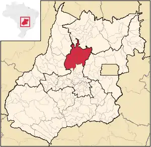
Die Mikroregion Ceres (portugiesisch Microrregião de Ceres) war eine von 1989 bis 2017 durch das Instituto Brasileiro de Geografia e Estatística (IBGE) für geostatistische Zwecke festgelegte Region im brasilianischen Bundesstaates Goiás. Sie gehörte zur Mesoregion Zentral-Goiás und umfasste 22 Gemeinden. Mikro- und Mesoregionen waren keine Verwaltungseinheiten. Das IBGE benutzt seit 2017 eine neue interne Einteilung.
| Mikroregion Ceres | |
|---|---|
| Karte | |
 Lage der Mikroregion Ceres in Goiás | |
| Basisdaten | |
| Staat: | |
| Bundesstaat: | |
| Mesoregion: | Zentral-Goiás |
| Angrenzende Mesoregionen: | Nord-Goiás, Ost-Goiás, Zentral-Goiás, Nordwest-Goiás |
| Angrenzende Mikroregionen: | Porangatu, Entorno de Brasília, Anápolis, Rio Vermelho, São Miguel do Araguaia |
| Zeitzone: | UTC-3 |
| Fläche: | 13.163,014 km² |
| Einwohner: | 224.842 IBGE: 2009 geschätzt[1] |
| Bevölkerungsdichte: | 17,1 Einwohner/km² |
| Anzahl d. Gemeinden: | 22 |
| Telefonvorwahl: | +5562 |
Geographische Lage
Die Mikroregion Ceres grenzte an die Mikroregionen (Mesoregionen):
- Im Norden an Porangatu (Nord-Goiás)
- Im Osten an Entorno de Brasília (Ost-Goiás)
- Im Süden an Anápolis (Zentral-Goiás)
- Im Südwesten an Rio Vermelho (Nordwest-Goiás)
- Im Nordwesten an São Miguel do Araguaia (Nordwest-Goiás)
Gemeinden in der Mikroregion Ceres
| Gemeinde | Lage | Fläche (km²) | Einwohner geschätzt 2009[1] | Einw./km² | BIP 2007 (Mio. R$) | BIP pro Kopf (R$) |
|---|---|---|---|---|---|---|
| Barro Alto |  Lage von Barro Alto in Goiás |
1.093,243 | 7.586 | |||
| Carmo do Rio Verde |  Lage von Carmo do Rio Verde in Goiás |
455,924 | 9.481 | |||
| Ceres |  Lage von Ceres in Goiás |
213,497 | 19.069 | |||
| Goianésia |  Lage von Goianésia in Goiás |
1.547,65 | 56.839 | |||
| Guaraíta |  Lage von Guaraíta in Goiás |
205,306 | 2.370 | |||
| Guarinos |  Lage von Guarinos in Goiás |
595,865 | 2.379 | |||
| Hidrolina |  Lage von Hidrolina in Goiás |
580,386 | 4.195 | |||
| Ipiranga de Goiás |  Lage von Ipiranga de Goiás |
241,464 | 2.906 | |||
| Itapaci |  Lage von Itapaci in Goiás |
956,126 | 17.086 | |||
| Itapuranga |  Lage von Itapuranga in Goiás |
1.277,160 | 25.170 | |||
| Morro Agudo de Goiás |  Lage von Morro Agudo de Goiás |
282,615 | 2.379 | |||
| Nova América |  Lage von Nova América in Goiás |
212,023 | 2.278 | |||
| Nova Glória |  Lage von Nova Glória in Goiás |
412,975 | 8.632 | |||
| Pilar de Goiás |  Lage von Pilar de Goiás |
906,648 | 2.821 | |||
| Rialma |  Lage von Rialma in Goiás |
268,958 | 10.911 | |||
| Rianápolis |  Lage von Rianápolis in Goiás |
159,345 | 4.256 | |||
| Rubiataba |  Lage von Rubiataba in Goiás |
748,273 | 18.618 | |||
| Santa Isabel |  Lage von Santa Isabel in Goiás |
806,814 | 3.575 | |||
| Santa Rita do Novo Destino |  Lage von Santa Rita do Novo Destino in Goiás |
956,037 | 3.576 | |||
| São Luíz do Norte |  Lage von São Luíz do Norte in Goiás |
586,060 | 4.456 | |||
| São Patrício |  Lage von São Patrício in Goiás |
134,518 | 2.144 | |||
| Uruana |  Lage von Uruana in Goiás |
522,127 | 14.115 | |||
Einzelnachweise
- Estimativas da população para 1º de julho de 2009, Instituto Brasileiro de Geografia e Estatística (IBGE) (portugiesisch; PDF; 5,3 MB)
This article is issued from Wikipedia. The text is licensed under Creative Commons - Attribution - Sharealike. Additional terms may apply for the media files.