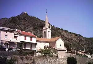
La Saulce
La Saulce ist eine französische Gemeinde im Département Hautes-Alpes in der Region Provence-Alpes-Côte d’Azur. Sie gehört zum Kanton Tallard im Arrondissement Gap.
| La Saulce | ||
|---|---|---|

|
| |
| Staat | Frankreich | |
| Region | Provence-Alpes-Côte d’Azur | |
| Département (Nr.) | Hautes-Alpes (05) | |
| Arrondissement | Gap | |
| Kanton | Tallard | |
| Gemeindeverband | Gap-Tallard-Durance | |
| Koordinaten | 44° 26′ N, 6° 1′ O | |
| Höhe | 555–1046 m | |
| Fläche | 7,89 km² | |
| Einwohner | 1.387 (1. Januar 2021) | |
| Bevölkerungsdichte | 176 Einw./km² | |
| Postleitzahl | 05110 | |
| INSEE-Code | 05162 | |
 La Saulce | ||

Geografie
Im Süden und im Südosten bildet die Durance die Grenze zu Curbans. Knapp an der Grenze zu Curbans mündet der Rousine in die Durance. Die weiteren Nachbargemeinden sind Tallard im Nordosten, Lardier-et-Valença im Westen und Fouillouse im Norden.
 Das Stauwehr von La Saulce und Curbans
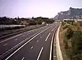 Die Autoroute A51 bei La Saulce
Bevölkerungsentwicklung
| Jahr | 1962 | 1968 | 1975 | 1982 | 1990 | 1999 | 2006 | 2018 |
|---|---|---|---|---|---|---|---|---|
| Einwohner | 567 | 565 | 688 | 638 | 632 | 905 | 1190 | 1490 |
Weblinks
Commons: La Saulce – Sammlung von Bildern, Videos und Audiodateien
This article is issued from Wikipedia. The text is licensed under Creative Commons - Attribution - Sharealike. Additional terms may apply for the media files.