Hao (Gemeinde)
Hao ist eine Gemeinde im Tuamotu-Archipel in Französisch-Polynesien.
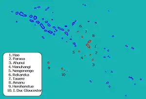
Die Gemeinde besteht aus 12 Atollen. Sie ist in 3 „Communes associées“ (Teilgemeinden) untergliedert. Der Hauptort der Gemeinde ist Hao. Der Code INSEE der Gemeinde ist 98720.

Position der Gemeinde Hao
![]() Karte mit allen Koordinaten: OSM | WikiMap
Karte mit allen Koordinaten: OSM | WikiMap
| Atoll oder Insel | Commune associée | Einwohner 2002 | Landfläche (km2) | Lagune (km2) | Post- leitzahl | Koordinaten |
|---|---|---|---|---|---|---|
| Hao | Hao | 1226 | 47 | 490 | 98767 | 18° 14′ S, 140° 53′ W |
| Ahunui | Hao | 0 | 5,7 | 16 | 19° 38′ S, 140° 25′ W | |
| Nengonengo | Hao | 50 | 9 | 67 | 18° 45′ S, 041° 48′ W | |
| Manuhangi | Hao | 0 | 1 | 7 | 19° 14′ S, 141° 15′ W | |
| Paraoa | Hao | 0 | 4 | 14 | 19° 08′ S, 140° 41′ W | |
| Amanu | Amanu | 165 | 9,6 | 240 | 98790 | 17° 48′ S, 140° 46′ W |
| Rekareka1 | Amanu | 0 | 1,6 | 2,5 | 16° 50′ S, 141° 55′ W | |
| Tauere | Amanu | ? | 2 | 60 | 98790 | 17° 22′ S, 141° 29′ W |
| Héréhérétué | Héréhérétué | 60 | 4 | 23 | 98790 | 19° 52′ S, 144° 58′ W |
| Anuanuraro | Héréhérétué | 0 | 2,2 | 11 | 20° 25′ S, 143° 31′ W | |
| Anuanurunga | Héréhérétué | 0 | 7 | 2,6 | 20° 38′ S, 143° 19′ W | |
| Nukutepipi | Héréhérétué | 0 | 0,6 | 1,3 | 20° 42′ S, 143° 03′ W | |
| Gemeinde Hao | 3 Communes associées | 1501 | 93,7 | 934 |
1 Das Atoll Rekareka wird auch Tehuata genannt
Die Gruppe der 3 unbewohnten Atolle Anuanuraro, Anuanuruga und Nukutepipi (alle zur Commune associée Héréhérétué gehörig) wird auch Duke of Gloucester Inseln genannt.
This article is issued from Wikipedia. The text is licensed under Creative Commons - Attribution - Sharealike. Additional terms may apply for the media files.