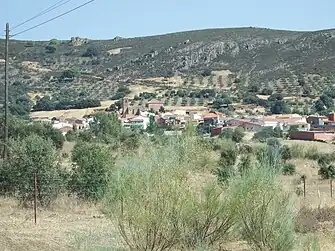
Fontanarejo
Fontanarejo ist eine Gemeinde mit 246 Einwohnern (Stand: 1. Januar 2022) in der spanischen Provinz Ciudad Real der Autonomen Region Kastilien-La Mancha.
| Gemeinde Fontanarejo | |||
|---|---|---|---|
 Fontanarejo | |||
| Wappen | Karte von Spanien | ||
 |
| ||
| Basisdaten | |||
| Land: | |||
| Autonome Gemeinschaft: | |||
| Provinz: | Ciudad Real | ||
| Comarca: | Montes | ||
| Gerichtsbezirk: | Ciudad Real | ||
| Koordinaten: | 39° 13′ N, 4° 31′ W | ||
| Höhe: | 647 msnm | ||
| Fläche: | 76,95 km² | ||
| Einwohner: | 246 (1. Jan. 2022)[1] | ||
| Bevölkerungsdichte: | 3 Einw./km² | ||
| Postleitzahl(en): | 13193 | ||
| Gemeindenummer (INE): | 13041 | ||
| Verwaltung | |||
| Bürgermeisterin: | Juliana Alcaide Muñoz (PP) | ||
| Website: | Fontanarejo | ||
| Lage des Ortes | |||
Karte anzeigen 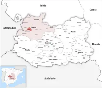 | |||

Lage
Fontanarejo befindet sich etwa 51 Kilometer westnordwestlich von Ciudad Real in einer Höhe von ca. 645 m.
Bevölkerungsentwicklung
| Jahr | 1970 | 1981 | 1991 | 2001 | 2011 | 2021 |
| Einwohner | 905 | 603 | 454 | 341 | 311 | 247[2] |
Sehenswürdigkeiten
- Philippus-und-Jakobus-Kirche (Iglesia de San Felipe y Santiago)
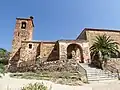 Philippus-und-Jakobus-Kirche
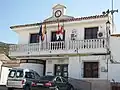 Rathaus
Einzelnachweise
- Cifras oficiales de población de los municipios españoles en aplicación de la Ley de Bases del Régimen Local (Art. 17). Instituto Nacional de Estadística (Bevölkerungsstatistiken des Instituto Nacional de Estadística, Stand 1. Januar 2022).
- Fontanarejo – Bevölkerungsentwicklung
Weblinks
Abenójar | Agudo | Alamillo | Albaladejo | Alcázar de San Juan | Alcoba | Alcolea de Calatrava | Alcubillas | Aldea del Rey | Alhambra | Almadén | Almadenejos | Almagro | Almedina | Almodóvar del Campo | Almuradiel | Anchuras | Arenales de San Gregorio | Arenas de San Juan | Argamasilla de Alba | Argamasilla de Calatrava | Arroba de los Montes | Ballesteros de Calatrava | Bolaños de Calatrava | Brazatortas | Cabezarados | Cabezarrubias del Puerto | Calzada de Calatrava | Campo de Criptana | Cañada de Calatrava | Caracuel de Calatrava | Carrión de Calatrava | Carrizosa | Castellar de Santiago | Chillón | Ciudad Real | Corral de Calatrava | Los Cortijos | Cózar | Daimiel | Fernán Caballero | Fontanarejo | Fuencaliente | Fuenllana | Fuente el Fresno | Granátula de Calatrava | Guadalmez | Herencia | Hinojosas de Calatrava | Horcajo de los Montes | Las Labores | Llanos del Caudillo | Luciana | Malagón | Manzanares | Membrilla | Mestanza | Miguelturra | Montiel | Moral de Calatrava | Navalpino | Navas de Estena | Pedro Muñoz | Picón | Piedrabuena | Poblete | Porzuna | Pozuelo de Calatrava | Los Pozuelos de Calatrava | Puebla de Don Rodrigo | Puebla del Príncipe | Puerto Lápice | Puertollano | Retuerta del Bullaque | El Robledo | Ruidera | Saceruela | San Carlos del Valle | San Lorenzo de Calatrava | Santa Cruz de los Cáñamos | Santa Cruz de Mudela | Socuéllamos | La Solana | Solana del Pino | Terrinches | Tomelloso | Torralba de Calatrava | Torre de Juan Abad | Torrenueva | Valdemanco del Esteras | Valdepeñas | Valenzuela de Calatrava | Villahermosa | Villamanrique | Villamayor de Calatrava | Villanueva de la Fuente | Villanueva de los Infantes | Villanueva de San Carlos | Villar del Pozo | Villarrubia de los Ojos | Villarta de San Juan | Viso del Marqués