East Redonda Island
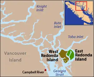
East Redonda Island ist eine Insel zwischen dem Festland der kanadischen Provinz British Columbia und Vancouver Island. Sie gehört zum Strathcona Regional District.
| East Redonda Island | |
|---|---|
| Gewässer | Salish Sea |
| Inselgruppe | Discovery Islands |
| Geographische Lage | 50° 15′ N, 124° 43′ W |
 Lage von East Redonda Island | |
| Höchste Erhebung | Mount Addenbroke 1591 m |
| Einwohner | unbewohnt |
Sie gehört zu den Discovery Islands und liegt am Ende des Toba Inlet.
| Pryce Channel → Toba Inlet | Pendrell Sound | |
| Waddington Channel → West Redonda Island | .svg.png.webp) |
Homfray Channel → Festland |
| Desolation Sound |
Mit dem Mount Addenbroke bestimmt ein 1591 m hoher Berg das Ökosystem der Insel.[1] Zum Schutz dieses besonderen Ökosystems wurde 1971 im Osten der Insel das 6.182 ha große Waldschutzgebiet East Redonda Island Ecological Reserve eingerichtet.
Geschichte
Die Insel wurde 1792 bei der Expedition von Dionisio Alcalá Galiano und Cayetano Valdés y Flores entdeckt und Isla Redonda genannt, was übersetzt Runde Insel heißt.[2]
Weblinks
- East Redonda Island. In: BC Geographical Names (englisch).
- East Redonda Island in der Canadian Geographical Names Data Base (CGNDB, englisch)
- Mount Addenbroke bei PeakBagger.com
Einzelnachweise
- Mount Addenbroke in der Internetversion der englischen Canadian Mountain Encyclopedia
- Andrew Scott: The Encyclopedia of Raincoast Place Names: A Complete Reference to Coastal British Columbia. Harbour Publishing, Madeira Park, BC 2009, ISBN 978-1-55017-484-7, S. 177 (englisch).
This article is issued from Wikipedia. The text is licensed under Creative Commons - Attribution - Sharealike. Additional terms may apply for the media files.