Castillo de Villamalefa
Castillo de Villamalefa ist eine Gemeinde (Municipio) mit 112 Einwohnern (Stand: 1. Januar 2022) in der Provinz Castellón in der spanischen autonomomen Region Valencia.
| Gemeinde Castillo de Villamalefa | |||
|---|---|---|---|
 | |||
| Wappen | Karte von Spanien | ||
 |
| ||
| Basisdaten | |||
| Land: | |||
| Autonome Gemeinschaft: | |||
| Provinz: | Castellón | ||
| Comarca: | Alto Mijares | ||
| Gerichtsbezirk: | Castellón de la Plana | ||
| Koordinaten: | 40° 8′ N, 0° 23′ W | ||
| Höhe: | 808 msnm | ||
| Fläche: | 37,74 km² | ||
| Einwohner: | 112 (1. Jan. 2022)[1] | ||
| Bevölkerungsdichte: | 3 Einw./km² | ||
| Postleitzahl(en): | 12123 | ||
| Gemeindenummer (INE): | 12041 | ||
| Verwaltung | |||
| Bürgermeister: | Diego Gallén Bou | ||
| Website: | Castillo de Villamalefa | ||
| Lage des Ortes | |||
Karte anzeigen  | |||

Geographie
Castillo de Villamalefa liegt etwa 40 Kilometer westnordwestlich der Provinzhauptstadt Castellón de la Plana und etwa 70 Kilometer nördlich von Valencia im Bezirk Alto Mijares in einer Höhe von ca. 810 m.
Bevölkerungsentwicklung der Gemeinde

Sehenswürdigkeiten
- Burgruine von Villamalefa
- Peterskirche
- Johannes-der-Täufer-Kapelle
- Kalvarienkapelle
 Burgruine
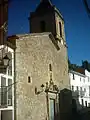 Peterskirche
 Kalvarienkapelle
 Rathaus
Weblinks
Einzelnachweise
- Cifras oficiales de población de los municipios españoles en aplicación de la Ley de Bases del Régimen Local (Art. 17). Instituto Nacional de Estadística (Bevölkerungsstatistiken des Instituto Nacional de Estadística, Stand 1. Januar 2022).

Aín | Albocàsser | Alcalà de Xivert | L’Alcora | Alcudia de Veo | Alfondeguilla | Algimia de Almonacid | Almassora | Almedíjar | Almenara | Les Alqueries | Altura | Arañuel | Ares del Maestrat | Argelita | Artana | Atzeneta del Maestrat | Ayódar | Azuébar | Barracas | Bejís | Benafer | Benafigos | Benassal | Benicarló | Benicàssim | Benlloc | Betxí | Borriana/Burriana | Borriol | Cabanes | Càlig | Canet lo Roig | Castell de Cabres | Castellfort | Castellnovo | Castelló de la Plana | Castillo de Villamalefa | Catí | Caudiel | Cervera del Maestre | Chóvar | Cinctorres | Cirat | Cortes de Arenoso | Costur | Les Coves de Vinromà | Culla | Eslida | Espadilla | Fanzara | Figueroles | Forcall | Fuente la Reina | Fuentes de Ayódar | Gaibiel | Geldo | Herbers | Higueras | La Jana | La Vall d’Uixó | Jérica | Lucena del Cid | Ludiente | La Llosa | La Mata de Morella | Matet | Moncofa | Montán | Montanejos | Morella | Navajas | Nules | Olocau del Rey | Onda | Orpesa/Oropesa del Mar | Palanques | Pavías | Peníscola/Peñíscola | Pina de Montalgrao | La Pobla de Benifassà | La Pobla Tornesa | Portell de Morella | Puebla de Arenoso | Ribesalbes | Rossell | Sacañet | La Salzadella | San Rafael del Río | Sant Joan de Moró | Sant Jordi/San Jorge | Sant Mateu | Santa Magdalena de Pulpis | La Serratella | Segorbe | Sierra Engarcerán | Soneja | Sot de Ferrer | Suera/Sueras | Tales | Teresa de Begís | Tírig | Todolella | Toga | Torás | El Toro | Torralba del Pinar | La Torre d’en Besora | La Torre d’en Doménec | Torreblanca | Torrechiva | Traiguera | Useras | Vall d’Alba | Vall de Almonacid | Vallat | Vallibona | Vilafamés | Vilafranca/Villafranca del Cid | Vilanova d’Alcolea | Vilar de Canes | Vila-real | La Vilavella | Villahermosa del Río | Villamalur | Villanueva de Viver | Villores | Vinaròs | Vistabella del Maestrat | Viver | Xert | Xilxes/Chilches | Xodos/Chodos | Zorita del Maestrazgo | Zucaina