Boismont (Meurthe-et-Moselle)
| Boismont | ||
|---|---|---|

|
| |
| Staat | Frankreich | |
| Region | Grand Est | |
| Département (Nr.) | Meurthe-et-Moselle (54) | |
| Arrondissement | Val-de-Briey | |
| Kanton | Mont-Saint-Martin | |
| Gemeindeverband | Terre Lorraine du Longuyonnais | |
| Koordinaten | 49° 24′ N, 5° 44′ O | |
| Höhe | 233–350 m | |
| Fläche | 5,43 km² | |
| Einwohner | 417 (1. Januar 2021) | |
| Bevölkerungsdichte | 77 Einw./km² | |
| Postleitzahl | 54620 | |
| INSEE-Code | 54081 | |
_%C3%A9coles_et_mairie.JPG.webp) Bürgermeisteramt (Mairie) und Schulen | ||
Boismont ist eine französische Gemeinde mit 417 Einwohnern (Stand 1. Januar 2021) im Département Meurthe-et-Moselle in der Region Grand Est (vor 2016 Lothringen). Sie gehört zum Arrondissement Val-de-Briey und ist Mitglied im Gemeindeverband Communauté de communes Terre Lorraine du Longuyonnais.
Geographie
Boismont liegt etwa 29 Kilometer westnordwestlich von Thionville und 15 Kilometer südlich von Longwy nahe dem Grenzgebiet zu Belgien und Luxemburg. Umgeben wird Boismont von den Nachbargemeinden Baslieux im Norden, Bazailles im Osten, Mercy-le-Bas im Südosten und Süden, Han-devant-Pierrepont im Süden und Südwesten sowie Pierrepont im Westen.
Bevölkerungsentwicklung
| Jahr | 1962 | 1968 | 1975 | 1982 | 1990 | 1999 | 2006 | 2019 |
| Einwohner | 586 | 525 | 474 | 378 | 437 | 456 | 452 | 422 |
| Quellen: Cassini und INSEE | ||||||||

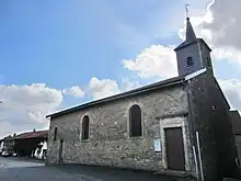
Pfarrkirche Notre-Dame-de-l’Assomption
Sehenswürdigkeiten
- Pfarrkirche Notre-Dame-de-l’Assomption, wieder errichtet 1827
Weblinks
Commons: Boismont – Sammlung von Bildern
This article is issued from Wikipedia. The text is licensed under Creative Commons - Attribution - Sharealike. Additional terms may apply for the media files.
