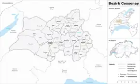
Bezirk Cossonay
Der District de Cossonay (dt. Bezirk Cossonay) war bis zum 31. August 2006 eine Verwaltungseinheit des Kantons Waadt in der Schweiz. Hauptort war Cossonay. Der District wurde in die vier Cercles (dt. Kreise) La Sarraz, Cossonay, L’Isle und Sullens aufgeteilt.
| District de Cossonay | |
|---|---|
| Basisdaten | |
| Staat: | |
| Kanton: | |
| Hauptort: | Cossonay |
| Fläche: | 198,37 km² |
| Einwohner: | 21'720 (31. Dezember 2006) |
| Bevölkerungsdichte: | 109 Einw. pro km² |
| Aufgehoben am: | 31. August 2006 |
| Karte | |
 Karte von District de Cossonay | |
Der District bestand aus 32 Gemeinden, war 198,37 km² gross und zählte 21'720 Einwohner (Ende 2006).
| Name der Gemeinde | Einwohner (31. Dez. 2006) |
Fläche in km² [1] |
Einw. pro km² |
Kreis (Cercle) |
|---|---|---|---|---|
| Chavannes-le-Veyron | 121 | 2,64 | 46 | Cossonay |
| Cossonay | 3153 | 8,28 | 381 | |
| Cottens (VD) | 390 | 2,35 | 166 | |
| Gollion | 595 | 5,45 | 109 | |
| Grancy | 345 | 5,67 | 61 | |
| La Chaux (Cossonay) | 378 | 6,74 | 56 | |
| Penthalaz | 2294 | 3,87 | 593 | |
| Senarclens | 333 | 3,97 | 84 | |
| Sévery | 207 | 2,38 | 87 | |
| Chevilly | 234 | 3,89 | 60 | La Sarraz |
| Dizy | 216 | 3,04 | 71 | |
| Eclépens | 944 | 5,80 | 163 | |
| Ferreyres | 255 | 3,16 | 81 | |
| La Sarraz | 1763 | 7,70 | 229 | |
| Lussery-Villars | 324 | 3,74 | 87 | |
| Moiry | 254 | 6,66 | 38 | |
| Orny | 368 | 5,55 | 66 | |
| Pompaples | 672 | 4,44 | 151 | |
| Cuarnens | 410 | 7,13 | 58 | L’Isle |
| L’Isle | 909 | 16,22 | 56 | |
| Mauraz | 52 | 0,50 | 104 | |
| Mont-la-Ville | 332 | 19,79 | 17 | |
| Montricher | 762 | 26,02 | 29 | |
| Pampigny | 901 | 11,09 | 81 | |
| Bettens | 305 | 3,74 | 82 | Sullens |
| Bournens | 248 | 3,91 | 63 | |
| Boussens | 751 | 3,16 | 238 | |
| Daillens | 732 | 5,52 | 133 | |
| Mex (VD) | 571 | 2,83 | 202 | |
| Penthaz | 1365 | 3,84 | 355 | |
| Sullens | 864 | 3,91 | 221 | |
| Vufflens-la-Ville | 1070 | 5,38 | 199 | |
| Bezirk Cossonay (32) | 21'720 | 198,37 | 109 | (4) |
Veränderungen im Gemeindebestand
 Gemeinden bis 1952
 Gemeinden bis 1998
 Gemeinden bis 2006
- 1. Januar 1953: Namensänderung von La Chaux VD → La Chaux (Cossonay)
- 1. Januar 1999: Fusion Lussery und Villars-Lussery → Lussery-Villars
- 1. September 2006: Bezirkswechsel der Gemeinden Bettens, Bournens, Boussens, Daillens, Lussery-Villars, Mex, Penthalaz, Penthaz, Sullens und Vufflens-la-Ville vom Bezirk Cossonay → Bezirk Gros-de-Vaud
- 1. September 2006: Bezirkswechsel aller restlichen Gemeinden des Bezirks Cossonay → Bezirk Morges
Einzelnachweise
This article is issued from Wikipedia. The text is licensed under Creative Commons - Attribution - Sharealike. Additional terms may apply for the media files.