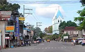
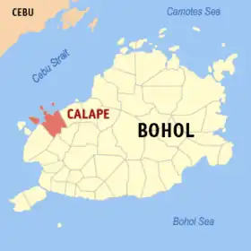
Calape
An Calape sarong ikaapat na klaseng banwaan kan probinsya nin Bohol, Filipinas. An designadong zip code kaini iyo 6328.
Sosog sa sensus kan 1 Mayo 2020, igwa ining 33,079 katawong nag-eerok digdi sa 7,938 kaharongan.
Calape | |
|---|---|
 | |
 Kinamumugtakan kan Calape | |
 | |
| Tagboan: 9°52′48″N 123°52′48″E | |
| Nasyon | Filipinas |
| Pigtugdas | 1802 |
| Barangay | 33 |
| Pamamahala | |
| • Electorado | 22,819 votantes (9 Mayo 2022) |
| Hiwas | |
| • Kabuuhan | 75.36 km2 (29.10 sq mi) |
| Elebasyon | 59 m (194 ft) |
| Populasyon (Mayo 1, 2020)[1] | |
| • kabuuhan | 33,079 |
| • Densidad | 440/km2 (1,100/sq mi) |
| • Saro | 7,938 |
| Economia | |
| • Klase | ikatolo na klaseng banwaan |
| • Ingresos | ₱138,566,761.94 (2020) |
| • Activos | ₱424,114,602.15 (2020) |
| • Pasivos | ₱60,723,950.70 (2020) |
| • Gastos | ₱120,528,213.42 (2020) |
| Kodigo nin postal | 6328 |
| PSGC | 071210000 |
| Kodigo telefonico | 38 |
| Tataramon | Diyalektong Boholano Tataramon na Cebuano tataramon na Tagalog |
Igwa ining sukol na 75.36 kilometro kwadrado.
Mga Barangay
An Calape nababanga sa 33 barangay.
|
|
|
Demograpiko
| Taon | Tawo | ±% p.a. |
|---|---|---|
| 1903 | 13,354 | — |
| 1918 | 18,392 | +2.16% |
| 1939 | 21,319 | +0.71% |
| 1948 | 21,383 | +0.03% |
| 1960 | 22,820 | +0.54% |
| 1970 | 20,888 | −0.88% |
| 1975 | 21,499 | +0.58% |
| 1980 | 22,488 | +0.90% |
| 1990 | 24,608 | +0.91% |
| 1995 | 26,051 | +1.07% |
| 2000 | 27,921 | +1.50% |
| 2007 | 29,786 | +0.90% |
| 2010 | 30,146 | +0.44% |
| 2015 | 30,863 | +0.45% |
| 2020 | 33,079 | +1.37% |
| Toltolan: Philippine Statistics Authority[2][3][4][5] | ||
Toltolan
- "2020 Census of Population and Housing (2020 CPH) Population Counts Declared Official by the President". Hulyo 7, 2021. Check date values in:
|date=(help) - Sensus kan Populasyon (2015). "Rehiyon VII (Sentral Bisaya)". Kabuuhang Populasyon kan lambang Provincia, Syudad, Banwaan asin Barangay. PSA. Retrieved 20 Jun 2016.
- Census of Population and Housing (2010). "Rehiyon VII (Sentral Bisaya)". Kabuuhan populasyon sa lambang Provincia, Syudad, Banwaan asin Barangay. NSO. Retrieved 29 Jun 2016.
- Mga Sensus kan Populasyon (1903–2007). "Rehiyon VII (Sentral Bisaya)". Table 1. Population Enumerated in Various Censuses by Province/Highly Urbanized City: 1903 to 2007. NSO.
- "Province of Bohol". Municipality Population Data. LWUA Research Division. Retrieved 17 December 2016.
Mga panluwas na takod
- PhilAtlas.com
- Philippine Standard Geographic Code
- Local Governance Performance Management System
- Calape
- Gothic-Inspired Church of Calape, Bohol Archived 2006-02-12 at the Wayback Machine.
- Municipality of Calape Archived 2009-01-24 at the Wayback Machine.
This article is issued from Wikipedia. The text is licensed under Creative Commons - Attribution - Sharealike. Additional terms may apply for the media files.