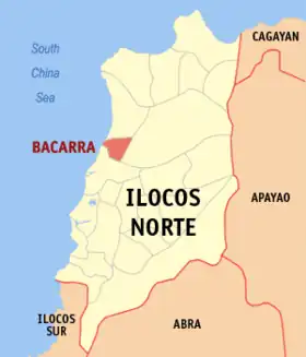
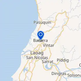
Bacarra
An Bacarra sarong ikaapat na klaseng banwaan sa provincia kan Ilocos Norte, Filipinas. An designadong zip code kaini iyo an 2916.
Sosog sa sensus kan 1 Mayo 2020, igwa ining 33,496 katawong nag-eerok digdi sa 8,620 kaharongan.
Bacarra | |
|---|---|
 | |
 Kinamumugtakan kan Bacarra | |
 | |
| Tagboan: 18°15′7″N 120°36′39″E | |
| Nasyon | Filipinas |
| Pigtugdas | 1778 |
| Barangay | 43 |
| Pamamahala | |
| • Electorado | 22,190 votantes (9 Mayo 2022) |
| Hiwas | |
| • Kabuuhan | 65.32 km2 (25.22 sq mi) |
| Elebasyon | 26 m (85 ft) |
| Populasyon (Mayo 1, 2020)[1] | |
| • kabuuhan | 33,496 |
| • Densidad | 510/km2 (1,300/sq mi) |
| • Saro | 8,620 |
| Economia | |
| • Klase | ikatolo na klaseng banwaan |
| • Ingresos | ₱145,303,858.86 (2020) |
| • Activos | ₱339,886,233.10 (2020) |
| • Pasivos | ₱66,562,631.41 (2020) |
| • Gastos | ₱143,273,163.13 (2020) |
| Kodigo nin postal | 2916 |
| PSGC | 012802000 |
| Kodigo telefonico | 77 |
| Tataramon | Tataramon na Ilokano tataramon na Tagalog |
| Websityo | www |

simbahan kan Bacarra
Igwa ining sukol na 65.32 kilometro kwadrado.

Leaning belfry kan Bacarra
Mga barangay
Nababanga an Bacarra sa 43 barangay.
- Bani
- Buyon
- Cabaruan
- Cabulalaan
- Cabusligan
- Cadaratan
- Calioet-Libong
- Casilian
- Corocor
- Duripes
- Ganagan
- Libtong
- Macupit
- Nambaran
- Natba
- Paninaan
- Pasiocan
- Pasngal
- Pipias
- Pulangi
- Pungto
- San Agustin I (Pob.)
- San Agustin II (Pob.)
- San Andres I (Pob.)
- San Andres II (Pob.)
- San Gabriel I (Pob.)
- San Gabriel II (Pob.)
- San Pedro I (Pob.)
- San Pedro II (Pob.)
- San Roque I (Pob.)
- San Roque II (Pob.)
- San Simon I Brgy# 4 (Pob.)
- San Simon II (Pob.)
- San Vicente (Pob.)
- Sangil
- Santa Filomena I (Pob.)
- Santa Filomena II (Pob.)
- Santa Rita (Pob.)
- Santo Cristo I (Pob.)
- Santo Cristo II (Pob.)
- Tambidao
- Teppang
- Tubburan
Demograpiko
| Taon | Tawo | ±% p.a. |
|---|---|---|
| 1903 | 14,616 | — |
| 1918 | 14,478 | −0.06% |
| 1939 | 14,806 | +0.11% |
| 1948 | 15,851 | +0.76% |
| 1960 | 18,570 | +1.33% |
| 1970 | 20,736 | +1.11% |
| 1975 | 22,118 | +1.30% |
| 1980 | 23,371 | +1.11% |
| 1990 | 26,940 | +1.43% |
| 1995 | 27,827 | +0.61% |
| 2000 | 29,668 | +1.38% |
| 2007 | 31,485 | +0.82% |
| 2010 | 31,648 | +0.19% |
| 2015 | 32,215 | +0.34% |
| 2020 | 33,496 | +0.77% |
| Toltolan: Philippine Statistics Authority[2][3][4][5] | ||
Toltolan
- "2020 Census of Population and Housing (2020 CPH) Population Counts Declared Official by the President". Hulyo 7, 2021. Check date values in:
|date=(help) - Sensus kan Populasyon (2015). "Rehiyon I (Rehiyon Ilocos)". Kabuuhang Populasyon kan lambang Provincia, Syudad, Banwaan asin Barangay. PSA. Retrieved 20 Jun 2016.
- Census of Population and Housing (2010). "Rehiyon I (Rehiyon Ilocos)". Kabuuhan populasyon sa lambang Provincia, Syudad, Banwaan asin Barangay. NSO. Retrieved 29 Jun 2016.
- Mga Sensus kan Populasyon (1903–2007). "Rehiyon I (Rehiyon Ilocos)". Table 1. Population Enumerated in Various Censuses by Province/Highly Urbanized City: 1903 to 2007. NSO.
- "Province of Ilocos Norte". Municipality Population Data. LWUA Research Division. Retrieved 17 December 2016.
Mga panluwas na takod
This article is issued from Wikipedia. The text is licensed under Creative Commons - Attribution - Sharealike. Additional terms may apply for the media files.