 | |||
| |||
| Alministración | |||
| Estáu federáu | |||
| Cantón | Cantón de Solothurn | ||
| Distrito (es) | Dorneck-Thierstein (en) | ||
| District of the canton of Solothurn (en) | Distritu de Thierstein | ||
| Tipu d'entidá | comuñes de Suiza | ||
| Nome oficial | Nunningen (de-ch) | ||
| Códigu postal |
4208 | ||
| Xeografía | |||
| Coordenaes | 47°23′39″N 7°37′10″E / 47.3942°N 7.6194°E | ||
 Nunningen Nunningen (Suiza)  | |||
| Superficie | 10.27 km² | ||
| Altitú | 621 m y 639 m | ||
| Demografía | |||
| Población | 1880 hab. (31 avientu 2018) | ||
| Porcentaxe |
? % de Distritu de Thierstein 100% de Dorneck-Thierstein (en) 0.69% de Cantón de Solothurn 0.02% de Suiza | ||
| Densidá | 183,06 hab/km² | ||
| Más información | |||
| Prefixu telefónicu |
061 | ||
| nunningen.ch | |||
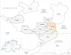
Nunningen ye una comuña suiza del cantón de Solothurn, allugada nel distritu de Thierstein. Llenda al norte coles comuñes de Himmelried y Seewen, al este con Bretzwil (BL) y Lauwil (BL), al sur con Beinwil, al suroeste con Meltingen, al oeste con Zullwil y Fehren, y al noroeste con Breitenbach.
Semeyes
Referencies
Enllaces esternos
This article is issued from Wikipedia. The text is licensed under Creative Commons - Attribution - Sharealike. Additional terms may apply for the media files.


