_mairie.jpg.webp) | |||
| |||
| Alministración | |||
| Departamentu | Meurthe (es) | ||
| Tipu d'entidá | comuña de Francia | ||
| Nome oficial | Hommarting (fr)[1] | ||
| Códigu postal |
57405 | ||
| Xeografía | |||
| Coordenaes | 48°44′19″N 7°08′43″E / 48.7386°N 7.1453°E | ||
 Hommarting Hommarting (Francia)  | |||
| Superficie | 10.19 km² | ||
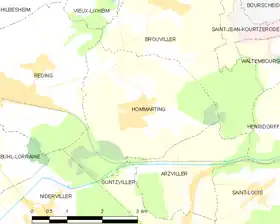
| Llenda con | Arzviller, Brouviller, Guntzviller, Niderviller y Réding | ||
| Demografía | |||
| Población |
824 hab. (1r xineru 2021) - 425 homes (2017) - 425 muyeres (2017) | ||
| Porcentaxe |
100% de Meurthe (es) | ||
| Densidá | 80,86 hab/km² | ||
| Más información | |||
| Estaya horaria |
UTC+01:00 (horariu estándar) UTC+02:00 (horariu de branu) | ||
| hommarting.fr | |||
Hommarting ye una comuña francesa del departamentu de Moselle, na rexón de Gran Este. Llenda con Arzviller, Brouviller, Guntzviller, Niderviller y Réding.
Tien una población de 824 hab. (1 xineru 2021)[2][3] y una superficie de 10,19[4] km².
Referencies
- ↑ «code officiel géographique». Consultáu'l 6 xineru 2019.
- ↑ Afirmao en: Populations légales 2021. Data d'espublización: 28 avientu 2023. Editorial: Institut national de la statistique et des études économiques.
- ↑ censu de población
- ↑ Afirmao en: répertoire géographique des communes. Data de consulta: 26 ochobre 2015. Editorial: Institut national de l'information géographique et forestière.
Enllaces esternos
.svg.png.webp) Sitiu web oficial (en francés)
Sitiu web oficial (en francés)
This article is issued from Wikipedia. The text is licensed under Creative Commons - Attribution - Sharealike. Additional terms may apply for the media files.