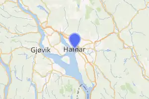
هامر (النرويج)
هامر : مدينة تقع إدارياً ضمن مقاطعة إينلاندت في النرويج.[4][5][6] وتبلغ مساحتها 350.94 كم².
| هامر | |
|---|---|
 | |
 | |
 | |
| الإحداثيات | 60°47′40″N 11°04′04″E |
| تقسيم إداري | |
| البلد | |
| التقسيم الأعلى | هامار |
| عاصمة لـ | |
| خصائص جغرافية | |
| المساحة | 350.94 كيلومتر مربع 13.89 كيلومتر مربع (4 نوفمبر 2019)[3] 12.17 كيلومتر مربع (4 نوفمبر 2019)[3] 1.49 كيلومتر مربع (4 نوفمبر 2019)[3] 0.23 كيلومتر مربع (4 نوفمبر 2019)[3] |
| ارتفاع | 150 متر |
| عدد السكان | |
| عدد السكان | 27947 (4 نوفمبر 2019)[3] |
| رمز جيونيمز | 3154084 |
مراجع
- "صفحة هامر (النرويج) في GeoNames ID". GeoNames ID. اطلع عليه بتاريخ 2024-03-23.
- "صفحة هامر (النرويج) في ميوزك برينز". MusicBrainz area ID. اطلع عليه بتاريخ 2024-03-23.
- "Tettsteders befolkning og areal" (بالنرويجية البوكمول). Statistisk sentralbyrå.
- Ramseth, Christian (1991). Hamar bys historie: til 50 års jubilæet 21 mars 1899 (بالنرويجية). Hamar Historical Society.
- Pedersen, Ragnar (1990). Den adelige frie sedegård Storhamar (Fra Kaupang og Bygd) (بالنرويجية). Hedmarksmuseet og Domkirkeodden. ISBN:82-990752-7-0.
- "Immigrants and Norwegian-born to immigrant parents, by immigration category, country background and percentages of the population" (بالإنجليزية). ssb.no. Archived from the original on 2015-07-02. Retrieved 2017-06-26.
- بوابة النرويج
- بوابة تجمعات سكانية
- بوابة جغرافيا
This article is issued from Wikipedia. The text is licensed under Creative Commons - Attribution - Sharealike. Additional terms may apply for the media files.