أوتاغو
أوتاغو (بالإنجليزية: Otago) (/əˈtɑːɡoʊ, oʊ-, ɒ-/;[4] New Zealand [əˈtɐːɡɐʉ̯] ⓘ)، هي أقليم من نيوزيلندا يق في جنوب الجزيرة الجنوبية التي يديرها مجلس أوتاغو الإقليمي. وتبلغ مساحتها حوالي 32,000 كيلومتر مربع (12,000 ميل2)،[5] مما يجعلها ثالث أكبر منطقة حكومية محلية في البلاد. في يونيو 2016، كان عدد سكانها 219,200 نسمة.
.jpg.webp)
Arrowtown, a historic mining town

جامعة أوتاغو، أقدم جامعة في نيوزيلندا
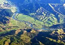
Aerial photo of Beaumont area in Otago, looking southwest. State Highway 8 runs from left to right across the photo (only visible in the right half), and crosses the Clutha River just below centre.

Mount Aspiring / Tititea is New Zealand's highest mountain outside the اوراكي/جبل كوك region.

Kawarau Gorge, where Roaring Meg joins the Kawarau River, in central Otago.
| المنطقة الحضرية | تعداد السكان ( يونيو 2018) [2] |
٪ من المنطقة |
|---|---|---|
| دنيدن[arabic-abajed 1] | 122,000 | 53٫2% |
| كوينزتاون | 15,850 | 6٫9% |
| Oamaru | 13,950 | 6٫1% |
| وانكا | 8,890 | 3٫9% |
| Alexandra | 5,510 | 2٫4% |
| Cromwell | 5,160 | 2٫3% |
| Balclutha | 3,990 | 1٫7% |
| Arrowtown | 2,950 | 1٫3% |
| Milton | 1,950 | 0٫9% |
| Waikouaiti | 1,170 | 0٫5% |
- Includes Mosgiel and ميناء تشالمرز.
| Largest groups of overseas-born residents[6][7] | |
| Nationality | Population (2013) |
|---|---|
| 12,486 | |
| 3,897 | |
| 1,719 | |
| 1,482 | |
| 1,182 | |
| 1,065 | |
| 969 | |
| 870 | |
| 846 | |
| 723 | |
| أوتاغو | ||
|---|---|---|
| Ōtākou | ||
| إقليم | ||
| ||
| ||
| الاسم الرسمي | Otago | |
 موقع أوتاغو ضمن نيوزيلندا | ||
| الإحداثيات | 45°17′S 169°56′E [1] | |
| Established | 1848 (Dunedin settlement) 1852 (Otago Province) 1989 (Otago Regional Council) | |
| تقسيم إداري | ||
| البلد | ||
| الجزيرة | الجزيرة الجنوبية | |
| مقر | دنيدن | |
| السلطة الإقليمية | القائمة ..
| |
| الحكومة | ||
| Chair | Stephen Woodhead | |
| خصائص جغرافية | ||
| Region | 31٬251 كم2 (12٬066 ميل2) | |
| عدد السكان (يونيو 2018)[2] | ||
| Region | 229,200 | |
| الكثافة السكانية | 7٫3/كم2 (19/ميل2) | |
| معلومات أخرى | ||
| منطقة زمنية | NZST (ت.ع.م+12) | |
| توقيت صيفي | NZDT (ت.ع.م +13) | |
| رمز جيونيمز | 6612109 | |
| أيزو 3166 | NZ-OTA[3] | |
| الموقع الرسمي | www.Otago.co.nz www.ORC.govt.nz | |

مراجع
- "صفحة أوتاغو في خريطة الشارع المفتوحة". OpenStreetMap. اطلع عليه بتاريخ 2024-03-23.
- "Subnational Population Estimates: At 30 June 2018 (provisional)". Statistics New Zealand. 23 أكتوبر 2018. اطلع عليه بتاريخ 2018-10-23. For urban areas, "Subnational population estimates (UA, AU), by age and sex, at 30 June 1996, 2001, 2006-18 (2017 boundaries)". Statistics New Zealand. 23 أكتوبر 2018. اطلع عليه بتاريخ 2018-10-23.
- MusicBrainz (بالإنجليزية), MetaBrainz Foundation, QID:Q14005
- Jones، Daniel (2003) [1917]، English Pronouncing Dictionary، Cambridge: Cambridge University Press، ISBN:3-12-539683-2
{{استشهاد}}: الوسيط غير المعروف|المحررين=تم تجاهله (مساعدة) - "About the Otago region". Otago Regional Council. مؤرشف من الأصل في 2019-03-28.
- "2013 Census QuickStats about culture and identity – Birthplace and people born overseas". Statistics New Zealand. مؤرشف من الأصل في 2017-11-23. اطلع عليه بتاريخ 2016-01-23.
- "Birthplace (detailed), for the census usually resident population count, 2001, 2006, and 2013 (RC, TA) – NZ.Stat". Statistics New Zealand. مؤرشف من الأصل في 2019-04-03. اطلع عليه بتاريخ 2016-01-23.
This article is issued from Wikipedia. The text is licensed under Creative Commons - Attribution - Sharealike. Additional terms may apply for the media files.