File:Railway map of Slovenia.png
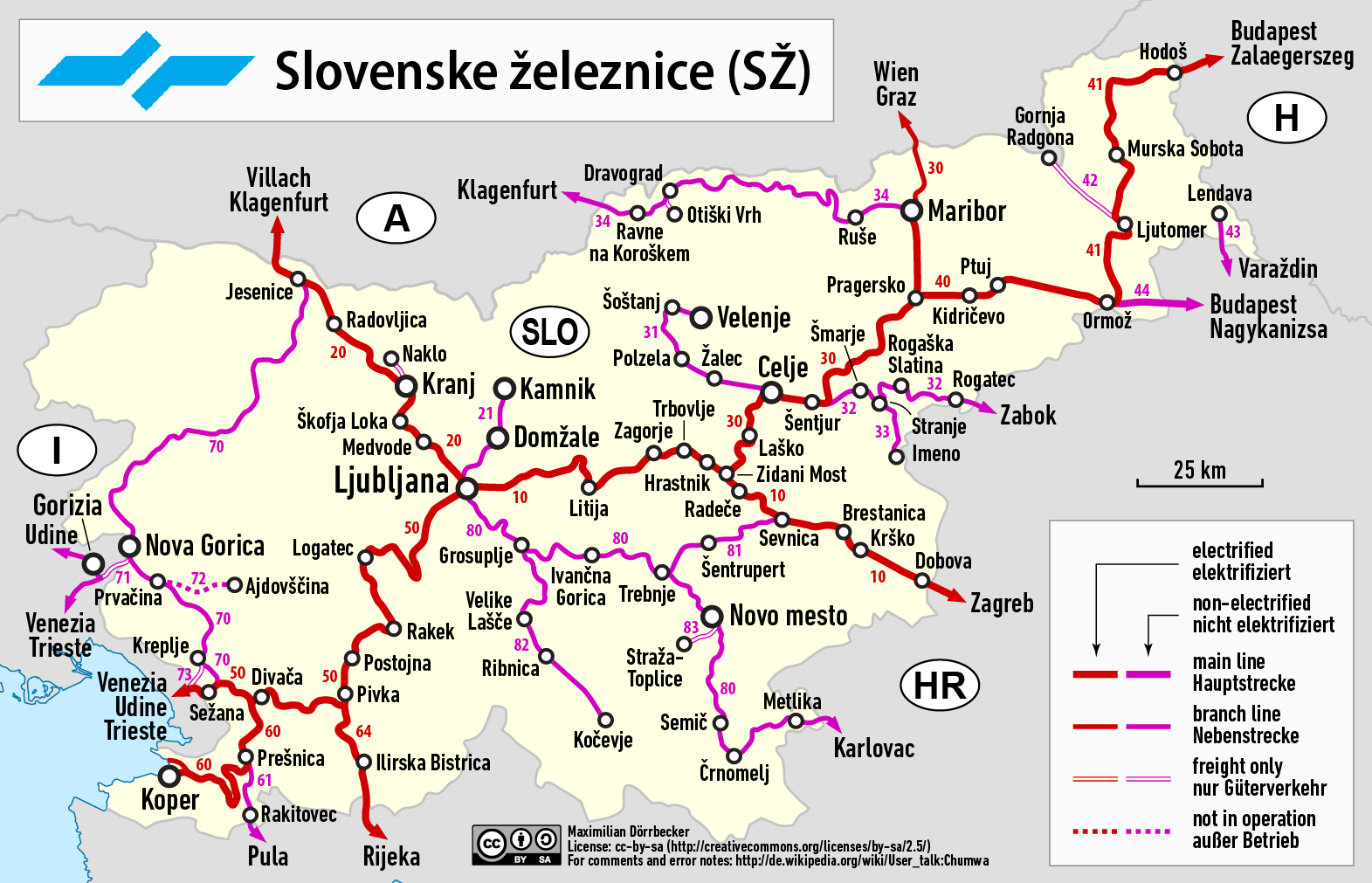
Size of this preview: 800 × 515 pixels. Other resolutions: 320 × 206 pixels | 640 × 412 pixels | 1,024 × 659 pixels | 1,571 × 1,011 pixels.
Original file (1,571 × 1,011 pixels, file size: 343 KB, MIME type: image/png)
Captions
Captions
Add a one-line explanation of what this file represents
| Description |
|
| Date | see file history |
| Source |
Own work using:
|
| Author | Maximilian Dörrbecker (Chumwa) |
| Permission (Reusing this file) |
I, the copyright holder of this work, hereby publish it under the following license: This file is licensed under the Creative Commons Attribution-Share Alike 2.5 Generic license.
Sie dürfen das Bild zu den folgenden Bedingungen nutzen:
|
File history
Click on a date/time to view the file as it appeared at that time.
| Date/Time | Thumbnail | Dimensions | User | Comment | |
|---|---|---|---|---|---|
| current | 15:45, 10 January 2021 | | 1,571 × 1,011 (343 KB) | Upwinxp (talk | contribs) | Grosuplje–Kočevje no longer freight-only since 3 January 2021 |
| 09:19, 1 December 2019 |  | 1,571 × 1,011 (315 KB) | Chumwa (talk | contribs) | Der Abzweigebahnhof der Strecke 33 von Strecke 32 ist falsch mit Grobelno bezeichnet: er heisst Stranje. | |
| 03:42, 29 May 2018 |  | 1,571 × 1,011 (315 KB) | Chumwa (talk | contribs) | Strecke 40 verläuft lt. dieser Quelle nur bis Ormož. Von dort bis zur ungarischen Grenze ist es Strecke 44. | |
| 15:30, 14 April 2018 |  | 1,964 × 1,264 (393 KB) | Chumwa (talk | contribs) | Ergänzung: Otiški Vrh | |
| 18:14, 6 April 2018 |  | 1,571 × 1,011 (314 KB) | Chumwa (talk | contribs) | corr | |
| 20:21, 22 June 2017 |  | 1,571 × 1,011 (314 KB) | Chumwa (talk | contribs) | corr | |
| 18:19, 15 May 2017 |  | 1,964 × 1,264 (388 KB) | Chumwa (talk | contribs) | {{Information |Description= *{{de|Eisenbahnkarte von Slowenien}} *{{en|Railway map of Slovenia}} |Source={{Own using}} *borders of Slovenia by {{U|NordNordWest}} *[http://www.bueker.net/trainspotting/map.php?file=map... |
You cannot overwrite this file.
File usage on Commons
The following 27 pages use this file:
- User:Chumwa/Gallery
- User:Chumwa/OgreBot/Potential transport maps/2017 June 21-30
- User:Chumwa/OgreBot/Potential transport maps/2017 May 11-20
- User:Chumwa/OgreBot/Potential transport maps/2018 April 1-10
- User:Chumwa/OgreBot/Potential transport maps/2018 April 11-20
- User:Chumwa/OgreBot/Potential transport maps/2018 May 21-31
- User:Chumwa/OgreBot/Potential transport maps/2019 December 1-10
- User:Chumwa/OgreBot/Public transport information/2017 June 21-30
- User:Chumwa/OgreBot/Public transport information/2017 May 11-20
- User:Chumwa/OgreBot/Public transport information/2018 April 1-10
- User:Chumwa/OgreBot/Public transport information/2018 April 11-20
- User:Chumwa/OgreBot/Public transport information/2018 May 21-31
- User:Chumwa/OgreBot/Public transport information/2019 December 1-10
- User:Chumwa/OgreBot/Public transport information/2021 January 1-10
- User:Chumwa/OgreBot/Transport Maps/2017 June 21-30
- User:Chumwa/OgreBot/Transport Maps/2017 May 11-20
- User:Chumwa/OgreBot/Transport Maps/2018 April 1-10
- User:Chumwa/OgreBot/Transport Maps/2018 April 11-20
- User:Chumwa/OgreBot/Transport Maps/2018 May 21-31
- User:Chumwa/OgreBot/Transport Maps/2019 December 1-10
- User:Chumwa/OgreBot/Transport Maps/2021 January 1-10
- User:Chumwa/OgreBot/Travel and communication maps/2017 June 21-30
- User:Chumwa/OgreBot/Travel and communication maps/2017 May 11-20
- User:Chumwa/OgreBot/Travel and communication maps/2018 April 1-10
- User:Chumwa/OgreBot/Travel and communication maps/2018 April 11-20
- User:Chumwa/OgreBot/Travel and communication maps/2018 May 21-31
- User:Chumwa/Railway maps
File usage on other wikis
The following other wikis use this file:
- Usage on az.wikipedia.org
- Usage on be-tarask.wikipedia.org
- Usage on be.wikipedia.org
- Usage on cs.wikipedia.org
- Usage on de.wikipedia.org
- Usage on en.wikipedia.org
- Usage on eo.wikipedia.org
- Usage on es.wikipedia.org
- Usage on fr.wikipedia.org
- Usage on fr.wikivoyage.org
- Usage on hr.wikipedia.org
- Usage on hu.wikipedia.org
- Usage on it.wikipedia.org
- Usage on ja.wikipedia.org
- Usage on nl.wikipedia.org
- Usage on no.wikipedia.org
- Usage on pl.wikipedia.org
- Usage on ro.wikipedia.org
- Usage on ru.wikipedia.org
- Usage on ru.wikivoyage.org
- Usage on sk.wikipedia.org
- Usage on sl.wikipedia.org
- Usage on sr.wikipedia.org
- Usage on sv.wikipedia.org
- Usage on tr.wikipedia.org
- Usage on uk.wikipedia.org
- Usage on www.wikidata.org
- Usage on zh.wikipedia.org