File:Protektorat Bohmen-Mahren.png

Size of this preview: 800 × 506 pixels. Other resolutions: 320 × 202 pixels | 640 × 404 pixels | 1,024 × 647 pixels | 1,280 × 809 pixels | 3,000 × 1,896 pixels.
Original file (3,000 × 1,896 pixels, file size: 1.21 MB, MIME type: image/png)
Captions
Captions
Add a one-line explanation of what this file represents

|
This locator map image could be re-created using vector graphics as an SVG file. This has several advantages; see Commons:Media for cleanup for more information. If an SVG form of this image is available, please upload it and afterwards replace this template with
{{vector version available|new image name}}.
It is recommended to name the SVG file “Protektorat Bohmen-Mahren.svg”—then the template Vector version available (or Vva) does not need the new image name parameter. |
Summary
edit
| Description |
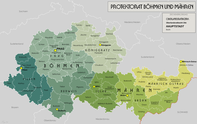
English: Administrative map of the Protectorate of Bohemia-Moravia |
| Date | 02/09/2008 |
| Source | Own work |
| Author | XrysD |
| Other versions | Derivative works of this file: Protektorat Bohmen-Mahren-2010-29-12.png |
Licensing
edit
I, the copyright holder of this work, hereby publish it under the following license:

|
Permission is granted to copy, distribute and/or modify this document under the terms of the GNU Free Documentation License, Version 1.2 or any later version published by the Free Software Foundation; with no Invariant Sections, no Front-Cover Texts, and no Back-Cover Texts. A copy of the license is included in the section entitled GNU Free Documentation License. |
| This file is licensed under the Creative Commons Attribution-Share Alike 3.0 Unported license. | ||
| ||
| This licensing tag was added to this file as part of the GFDL licensing update. |
File history
Click on a date/time to view the file as it appeared at that time.
| Date/Time | Thumbnail | Dimensions | User | Comment | |
|---|---|---|---|---|---|
| current | 17:37, 21 January 2020 | | 3,000 × 1,896 (1.21 MB) | XrysD (talk | contribs) | Tippfehler: Güding-->Göding |
| 15:30, 28 May 2018 |  | 3,000 × 1,896 (1.28 MB) | XrysD (talk | contribs) | Tippfehler Iglaü-->Iglau | |
| 12:33, 13 May 2015 |  | 3,000 × 1,896 (1,012 KB) | RokerHRO (talk | contribs) | optipng -o7 -i0 → 19.11% decrease | |
| 15:32, 11 March 2014 |  | 3,000 × 1,896 (1.22 MB) | XrysD (talk | contribs) | Line thickness increased and some labels darkened to improve clarity and legibility. | |
| 16:51, 3 March 2014 |  | 3,000 × 1,896 (1.15 MB) | XrysD (talk | contribs) | Die Karte wird komplett neu erstellt. Neue Datei digitalisiert aus dem Karte des Deutschen Reiches 1:100 000. | |
| 19:23, 27 May 2012 |  | 1,588 × 1,066 (1.04 MB) | XrysD (talk | contribs) | Uploaded wrong file | |
| 18:50, 27 May 2012 |  | 1,588 × 1,066 (1.04 MB) | XrysD (talk | contribs) | Fixed typo Koniggratz | |
| 18:21, 27 May 2012 |  | 1,588 × 1,066 (1.04 MB) | XrysD (talk | contribs) | Corrected typos Iglau and Koniginhof | |
| 17:38, 27 May 2012 |  | 1,588 × 1,066 (1.04 MB) | XrysD (talk | contribs) | Changed colours to full Bartholomew set. Added legend. Changed title font. Note there is an English language version of this file now that can be found at File:Protectorate Of Bohemia and Moravia.png | |
| 18:21, 9 August 2011 |  | 1,588 × 1,066 (346 KB) | XrysD (talk | contribs) | Fixed typo in Sudetenland, improved kerning on dash in Bohmen-Mahren, added signature. |
You cannot overwrite this file.
File usage on Commons
The following 4 pages use this file:
File usage on other wikis
The following other wikis use this file:
- Usage on az.wikipedia.org
- Usage on ba.wikipedia.org
- Usage on be-tarask.wikipedia.org
- Usage on be.wikipedia.org
- Usage on br.wikipedia.org
- Usage on ca.wikipedia.org
- Usage on cs.wikipedia.org
- Usage on de.wikipedia.org
- Usage on eo.wikipedia.org
- Usage on es.wikipedia.org
- Usage on fr.wikipedia.org
- Usage on hu.wikipedia.org
- Usage on it.wikipedia.org
- Usage on lv.wikipedia.org
- Usage on nl.wikipedia.org
- Usage on pl.wikipedia.org
- Usage on ro.wikipedia.org
- Usage on ru.wikipedia.org
- Usage on uk.wikipedia.org
- Usage on www.wikidata.org