File:Karte der S-Bahn München.png
Size of this preview: 700 × 600 pixels. Other resolutions: 280 × 240 pixels | 560 × 480 pixels | 896 × 768 pixels | 1,195 × 1,024 pixels | 2,140 × 1,834 pixels.
Original file (2,140 × 1,834 pixels, file size: 2.44 MB, MIME type: image/png)
Captions
Captions
Add a one-line explanation of what this file represents
| Description |
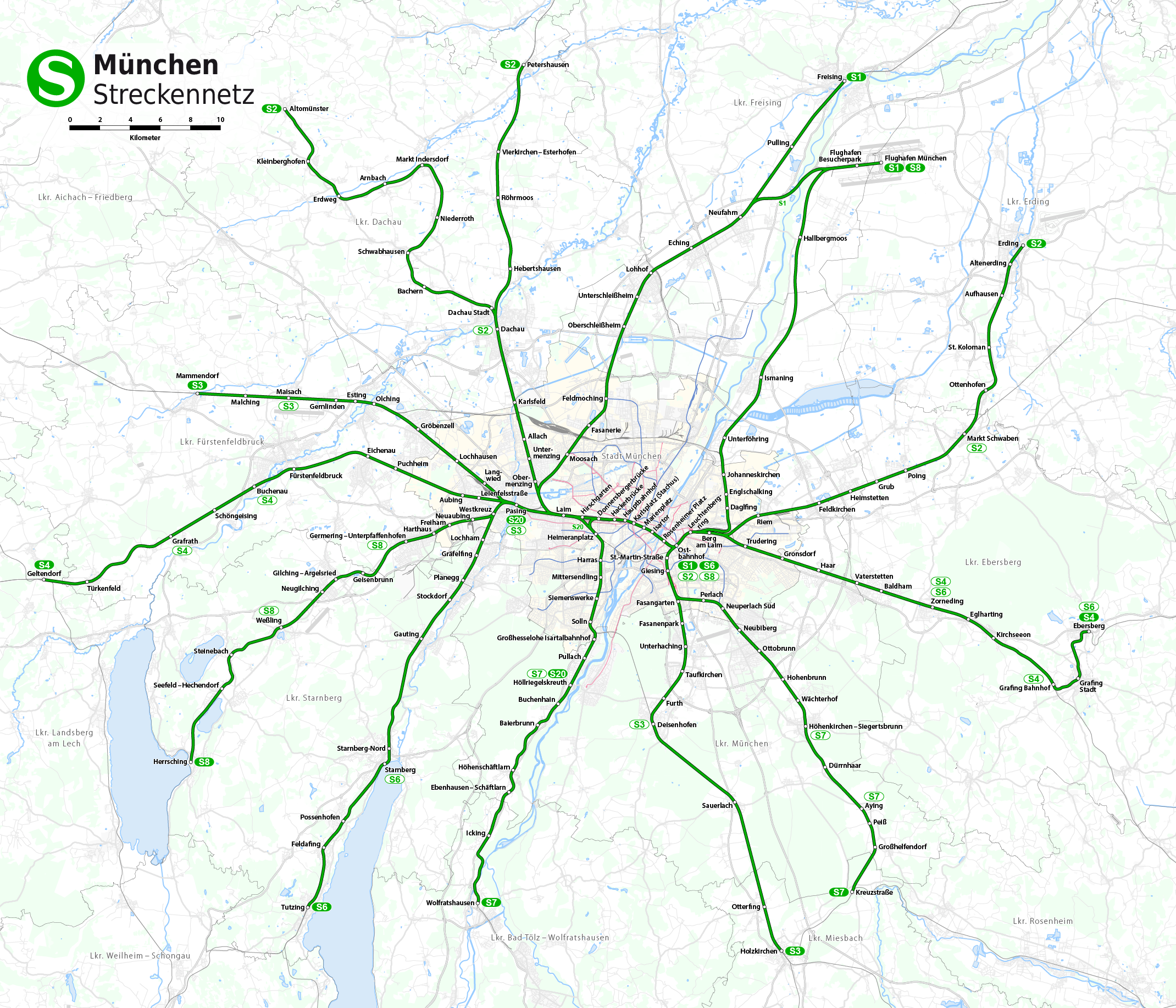
Deutsch: Streckennetz der S-Bahn München
English: Map of the Munich S-Bahn
Français : Plan du RER de Munich |
| Date | see file history |
| Source | Own work, using OpenStreetMap data for the background |
| Author | Maximilian Dörrbecker (Chumwa) |
| Permission (Reusing this file) |
All OpenStreetMap data and maps are Creative Commons "CC-BY-SA 2.0" licensed This file is licensed under the Creative Commons Attribution-Share Alike 2.0 Generic license.
|
| Other versions |
Weitere Münchner ÖPNV-Pläne:
|


File history
Click on a date/time to view the file as it appeared at that time.
| Date/Time | Thumbnail | Dimensions | User | Comment | |
|---|---|---|---|---|---|
| current | 06:35, 13 December 2014 | | 2,140 × 1,834 (2.44 MB) | Chumwa (talk | contribs) | Fahrplanwechsel 14.12.2014 |
| 23:03, 1 January 2014 |  | 2,015 × 1,706 (2.17 MB) | Chumwa (talk | contribs) | S27 verkehrt nicht mehr | |
| 22:38, 1 January 2014 |  | 2,015 × 1,706 (2.17 MB) | Chumwa (talk | contribs) | ||
| 06:37, 13 December 2010 |  | 2,140 × 1,833 (2.39 MB) | Chumwa (talk | contribs) | Verstärkerlinien ergänzt | |
| 17:31, 10 December 2010 |  | 2,140 × 1,833 (2.39 MB) | Chumwa (talk | contribs) | U3 nach Moosach verlängert | |
| 18:31, 6 April 2010 |  | 2,140 × 1,833 (2.39 MB) | Chumwa (talk | contribs) | diverse Korrekturen | |
| 15:21, 13 February 2010 |  | 2,014 × 1,705 (2.12 MB) | Chumwa (talk | contribs) | {{Information |Description={{de|Streckennetz der S-Bahn München}} {{en|Map of the Munich S-Bahn}} {{fr|Plan du RER de Munich}} |Author=Maximilian Dörrbecker (Chumwa) |Source={{own}}, using OpenStreetMap data |
You cannot overwrite this file.
File usage on Commons
The following 67 pages use this file:
- München
- S-Bahn in Germany
- User:Chumwa/Gallery
- User:Chumwa/OtherVersions - Karten München
- User:Chumwa/OtherVersions - ÖPNV-Karten München
- User:Chumwa/Railway maps
- File:Administrative boundaries of the borough of Solln in Munich.png
- File:Basiskarte Kiel.png
- File:Gleis 93.jpg
- File:Gleis 96.jpg
- File:Gleis 97b.jpg
- File:Karte Flaucher München.png
- File:Karte München - WirtshausWiesn 2020.png
- File:Karte München Basiskarte.jpg
- File:Karte München Basiskarte.png
- File:Karte München Landnutzung.png
- File:Karte München Schwarzplan.png
- File:Karte München ÖPNV.png
- File:Karte München Übersichtsplan.png
- File:Karte Streetlife München.png
- File:Karte Viktualienmarkt München.png
- File:Karte der Burgfrieden von München.png
- File:Karte der Denkmalschutzensembles in München.jpg
- File:Karte der Gemarkungen in München.png
- File:Karte der Gemarkungen und Stadtbezirke in München.png
- File:Karte der Ortsbezeichnungen in München.png
- File:Karte der Parkstadt Bogenhausen in München.png
- File:Karte der S-Bahn München.png
- File:Karte der Stadtbezirke in München.png
- File:Karte der Stadtbezirke in München in der bis 1992 gültigen Gliederung.png
- File:Karte der Stadtbezirksteile in München.png
- File:Karte der geplanten U9-Spange der U-Bahn München.png
- File:Linienband U-Bahn München.png
- File:Metrobusnetzplan München.png
- File:MuenchenSBahnMitSuedring.png
- File:MuenchenSBahnMitZweitemTunnel.png
- File:München - Basiskarte farbig.pdf
- File:München - Basiskarte farbig.png
- File:München - Basiskarte farbig - mit Nachbargemeinden.jpg
- File:München - Basiskarte farbig - mit Nachbargemeinden.png
- File:München - Basiskarte grau.pdf
- File:München - Basiskarte grau.png
- File:München - Stadtbezirke (Karte).png
- File:Positionskarte München.png
- File:Schnellbahnplan München.png
- File:SchnellbahnschemaplanMuenchenTopographisch2006.png
- File:SchnellbahnschemaplanMuenchenTopographisch2007.png
- File:Stadterweiterungen München.png
- File:StrassenbahnSchemaplanMuenchen1997.png
- File:StrassenbahnnetzMuenchen1964.jpg
- File:Straßenbahn-Linienplan München.png
- File:Straßenbahnnetzplan München.png
- File:Streckennetz der S-Bahn München.jpg
- File:U-Bahn-Plan München.png
- File:UBahnLinienbandMuenchen2006.png
- File:UBahnLinienbandMuenchen2007.png
- File:UBahnMuenchen Stammstrecke3.png
- File:UBahnSchemaplanMuenchenTopographisch2006.png
- File:UBahnSchemaplanMuenchenTopographisch2007.png
- File:UBahnSchemaplanMuenchenTopographisch2008.png
- File:VerkehrsnetzMuenchen2006.png
- File:VerkehrsnetzMuenchen2007.png
- File:VerkehrsnetzMünchen2005.png
- File:Verkehrsnetz München.png
- File:Verkehrsnetz München 2007.png
- File:Westpark München (Karte).png
- File:Westpark München zur IGA 1983 (Karte).png
.png)
.png)
.png)
File usage on other wikis
The following other wikis use this file:
- Usage on de.wikipedia.org
- Usage on en.wikipedia.org
- Usage on fi.wikipedia.org
- Usage on hu.wikipedia.org
- Usage on ru.wikipedia.org
- Usage on uk.wikipedia.org
- Usage on vi.wikipedia.org
- Usage on www.wikidata.org
- Usage on zh.wikipedia.org