File:Dnieper Basin River Town Polski.png

Size of this preview: 583 × 600 pixels. Other resolutions: 233 × 240 pixels | 467 × 480 pixels | 746 × 768 pixels | 1,180 × 1,214 pixels.
Original file (1,180 × 1,214 pixels, file size: 129 KB, MIME type: image/png)
Captions
Captions
Add a one-line explanation of what this file represents
| Description |
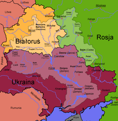
English: Polish map of the Dnepr River Basin
Polski: Zlewnia Dniepru |
||||||||
| Date | |||||||||
| Source | Francis McLloyd | ||||||||
| Author | Francis McLloyd | ||||||||
| Permission (Reusing this file) |
I, Francis McLloyd, the copyright holder of this work, hereby publishes it under the following licenses:
This file is licensed under the Creative Commons Attribution 2.5 Generic license. Attribution: I, Francis McLloyd
You may select the license of your choice. |
||||||||
| Other versions |
For a map in your language, ask Francis McLloyd.
|


|
Informacje autorskie takie jak dane autora, adresy www lub email, sygnatury itd zostały usunięte z niniejszego obrazu i przeniesione na stronę jego opisu. Dzięki temu obraz jest łatwiejszy do wykorzystania i bardziej neutralny językowo; dodatkowo informacje w formie tekstowej są łatwiejsze do wyszukiwania.
Serwis Commons zdecydowanie odradza umieszczane informacji o autorstwie wprost na obrazie. Miejscem na te informacje są strona opisu pliku i pola EXIF.
|

|
This map image could be re-created using vector graphics as an SVG file. This has several advantages; see Commons:Media for cleanup for more information. If an SVG form of this image is available, please upload it and afterwards replace this template with
{{vector version available|new image name}}.
It is recommended to name the SVG file “Dnieper Basin River Town Polski.svg”—then the template Vector version available (or Vva) does not need the new image name parameter. |
File history
Click on a date/time to view the file as it appeared at that time.
| Date/Time | Thumbnail | Dimensions | User | Comment | |
|---|---|---|---|---|---|
| current | 14:32, 18 September 2017 | | 1,180 × 1,214 (129 KB) | Nicolay Sidorov (talk | contribs) | ... |
| 08:37, 7 March 2007 |  | 1,180 × 1,214 (396 KB) | Dcoetzee (talk | contribs) | Removed watermark, pngcrushed | |
| 15:29, 14 February 2006 |  | 1,180 × 1,214 (601 KB) | Francis McLloyd (talk | contribs) | Category:Maps of Ukraine Category:Maps of countries |
You cannot overwrite this file.
File usage on Commons
The following 5 pages use this file:
File usage on other wikis
The following other wikis use this file:
- Usage on ceb.wikipedia.org
- Usage on cs.wikipedia.org
- Usage on da.wikipedia.org
- Usage on de.wikipedia.org
- Usage on en.wikipedia.org
- Usage on fa.wikipedia.org
- Usage on fr.wikipedia.org
- Usage on gl.wikipedia.org
- Usage on id.wikipedia.org
- Usage on nn.wikipedia.org
- Mal:Dnepr
- Dnepr
- Berezina
- Drut
- Pripjat
- Sozj
- Vorskla
- Psel
- Desna
- Vop
- Vjazma ved Dnepr
- Khmost
- Dnepr-reservoaret
- Kamjanske-reservoaret
- Kakhovka-reservoaret
- Kaniv-reservoaret
- Kiev-reservoaret
- Krementsjuk-reservoaret
- Bazavluk
- Inhulets
- Irpin-elva
- Roselva
- Samara ved Dnepr
- Stuhna
- Sulaelva
- Teteriv
- Trubizj
- Tjasmyn
- Zolotonosjka
- Konka
- Usage on pl.wikipedia.org
- Usage on tr.wikipedia.org
- Usage on uk.wikipedia.org