File:Myrar hnokki.svg

Size of this PNG preview of this SVG file: 516 × 600 pixels. Other resolutions: 206 × 240 pixels | 413 × 480 pixels | 661 × 768 pixels | 881 × 1,024 pixels | 1,762 × 2,048 pixels | 622 × 723 pixels.
Original file (SVG file, nominally 622 × 723 pixels, file size: 282 KB)
Captions
Captions
Add a one-line explanation of what this file represents
| I, the copyright holder of this work, release this work into the public domain. This applies worldwide. In some countries this may not be legally possible; if so: I grant anyone the right to use this work for any purpose, without any conditions, unless such conditions are required by law. |
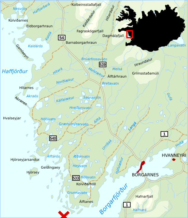
| Description | Map of the region Myrar in western Iceland with several toponyms showing the location of the reef Hnokki, south of Álftanes, where the research ship Pourquoi Pas ? of Jean-Baptiste Charcot, stranded on September 16, 1936. |
| Date | |
| Source | Own work |
| Author | Akigka |
| Other versions |
|


File history
Click on a date/time to view the file as it appeared at that time.
| Date/Time | Thumbnail | Dimensions | User | Comment | |
|---|---|---|---|---|---|
| current | 02:13, 20 April 2007 | | 622 × 723 (282 KB) | Akigka (talk | contribs) | {{Information |Description=Map of the region Myrar in western Iceland with several toponyms showing the location of the reef ''Hnokki'', south of Álftanes, where the research ship ''Pourquoi Pas ?'' of Jean-Baptiste Charcot, stranded on September 16, 193 |
You cannot overwrite this file.
File usage on Commons
The following 3 pages use this file:
File usage on other wikis
The following other wikis use this file:
- Usage on en.wikipedia.org
- Usage on is.wikipedia.org
- Usage on ru.wikipedia.org
- Usage on uk.wikipedia.org