File:Fils Hasental-Plochingen-Landsat7 WW texted.jpg

Size of this preview: 800 × 588 pixels. Other resolutions: 320 × 235 pixels | 640 × 471 pixels | 1,024 × 753 pixels | 1,280 × 941 pixels | 1,500 × 1,103 pixels.
Original file (1,500 × 1,103 pixels, file size: 1.86 MB, MIME type: image/jpeg)
Captions
Captions
Add a one-line explanation of what this file represents
| Description |
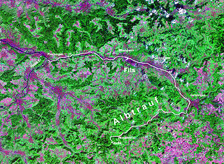
Landsat7 NASA-WorldWind image, GeoCover 2000 (s==>n, 4 km) Deutsch: Verlauf der Fils von der Quelle auf der Schwäbischen Alb bis zur Mündung in den Neckar bei Plochingen
|
| Date | |
| Source | NASA, WorldWind |
| Author | Photograph: NASA |
| Permission (Reusing this file) |
NASA PD-WorldWind |
| This image is in the public domain because it is a screenshot from NASA’s globe software World Wind using a public domain layer, such as Blue Marble, MODIS, Landsat, SRTM, USGS or GLOBE.
|
 |
File history
Click on a date/time to view the file as it appeared at that time.
| Date/Time | Thumbnail | Dimensions | User | Comment | |
|---|---|---|---|---|---|
| current | 21:38, 30 July 2007 | | 1,500 × 1,103 (1.86 MB) | Ustill (talk | contribs) | {{Information|Landsat7 NASA-WorldWind image, GeoCover 2000 (s==>n, 4 km) |Description ={{de|Verlauf der Fils von der Quelle auf der Schwäbischen Alb bis zur Mündung in den Neckar bei Plochingen {{en|River Fils, [[:en:Swabian_Alb |
You cannot overwrite this file.
File usage on Commons
There are no pages that use this file.
File usage on other wikis
The following other wikis use this file:
- Usage on als.wikipedia.org
- Usage on da.wikipedia.org
- Usage on fa.wikipedia.org
- Usage on it.wikipedia.org
- Usage on ja.wikipedia.org
- Usage on no.wikipedia.org