File:Baden Karte Kreise 1832 Extrakt Ober-Rheinkreis.jpg

Size of this preview: 677 × 600 pixels. Other resolutions: 271 × 240 pixels | 542 × 480 pixels | 867 × 768 pixels | 1,052 × 932 pixels.
Original file (1,052 × 932 pixels, file size: 771 KB, MIME type: image/jpeg)
Captions
Captions
Add a one-line explanation of what this file represents
Summary
edit
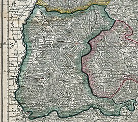
| Description | Charte über das Grossherzogthum Baden von 1820 ergänzt um die Grenzen der Kreiseinteilung 1832-1864 - Ausschnitt Mittel-Rheinkreis |
| Date | |
| Source | Charte über das Grossherzogthum Baden Digitalisat der UB Heidelberg |
| Author | Johann Gottfried Tulla, Franz Xaver Hutter |
Licensing
edit
|
This work is in the public domain in its country of origin and other countries and areas where the copyright term is the author's life plus 70 years or fewer. | |
| This file has been identified as being free of known restrictions under copyright law, including all related and neighboring rights. | |
File history
Click on a date/time to view the file as it appeared at that time.
| Date/Time | Thumbnail | Dimensions | User | Comment | |
|---|---|---|---|---|---|
| current | 19:00, 21 April 2021 | | 1,052 × 932 (771 KB) | Zieglhar (talk | contribs) | {{Information |Description=Charte über das Grossherzogthum Baden von 1820 ergänzt um die Grenzen der Kreiseinteilung 1832-1864 - Ausschnitt Mittel-Rheinkreis |Source=Charte über das Grossherzogthum Baden [https://digi.ub.uni-heidelberg.de/diglit/rothe13 Digitalisat der UB Heidelberg] |Date=1880 |Author=Johann Gottfried Tulla, Franz Xaver Hutter |Permission= |other_versions= }} Category:Maps of Baden (Kreise 1832-1864) |
You cannot overwrite this file.
File usage on Commons
The following page uses this file:
File usage on other wikis
The following other wikis use this file:
- Usage on als.wikipedia.org
- Usage on de.wikipedia.org
- Usage on www.wikidata.org