File:Saint-Barthélemy Island topographic map-de.svg

Size of this PNG preview of this SVG file: 800 × 533 pixels. Other resolutions: 320 × 213 pixels | 640 × 427 pixels | 1,024 × 683 pixels | 1,280 × 853 pixels | 2,560 × 1,707 pixels | 2,430 × 1,620 pixels.
Original file (SVG file, nominally 2,430 × 1,620 pixels, file size: 877 KB)
Captions
Captions
Add a one-line explanation of what this file represents
Summary
edit| Camera location | | View this and other nearby images on: OpenStreetMap |
|---|
| Description |
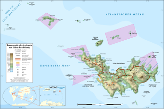
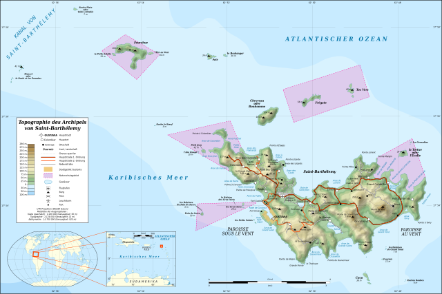
Deutsch: Topographische Karte in Deutsch des Karibischen Inselarchipels von Saint-Barthélemy. Hinweis: Das Relief ist als Rasterbild in der SVG-Datei eingebettet. English: Topographic map in French of the Caribbean archipelago of Saint Barthélemy.
Note: the shaded relief is a raster image embedded in the SVG file. Français : Carte topographique en français de l'archipel de Saint-Barthélemy dans les Petites Antilles. Notes : le relief ombré est une image bitmap embarquée dans le fichier SVG. Une grande partie de l'île étant occupée par les habitations et les maisons étant éparses, seule la zone urbaine de Gustavia a été représentée.
|
||
| Date | 2010-08, updated 2015-10 | ||
| Source |
Own work
|
||
| Author | Eric Gaba (Sting - fr:Sting), German translation by Lencer | ||
| Permission (Reusing this file) |
|
||
| Other versions |
|


|
This map has been made or improved in the German Kartenwerkstatt (Map Lab). You can propose maps to improve as well.
|

|
This SVG file contains embedded text that can be translated into your language, using any capable SVG editor, text editor or the SVG Translate tool. For more information see: About translating SVG files. |
Licensing
edit
Eric Gaba (Wikimedia Commons user Sting) and OpenStreetMap (and) contributors, the copyright holder of this work, hereby publishes it under the following license:
This file is licensed under the Creative Commons Attribution-Share Alike 2.0 Generic license.
Attribution: Eric Gaba (Wikimedia Commons user Sting) and OpenStreetMap (and) contributors
- You are free:
- to share – to copy, distribute and transmit the work
- to remix – to adapt the work
- Under the following conditions:
- attribution – You must give appropriate credit, provide a link to the license, and indicate if changes were made. You may do so in any reasonable manner, but not in any way that suggests the licensor endorses you or your use.
- share alike – If you remix, transform, or build upon the material, you must distribute your contributions under the same or compatible license as the original.
File history
Click on a date/time to view the file as it appeared at that time.
| Date/Time | Thumbnail | Dimensions | User | Comment | |
|---|---|---|---|---|---|
| current | 23:48, 17 October 2015 | | 2,430 × 1,620 (877 KB) | Sting (talk | contribs) | Using NASA SRTM 1 topographic data |
| 05:14, 31 August 2010 |  | 2,430 × 1,620 (815 KB) | Lencer (talk | contribs) | fix | |
| 17:03, 27 August 2010 |  | 2,430 × 1,620 (815 KB) | Lencer (talk | contribs) | {== {{int:filedesc}} == {{Location|17|55|00|N|62|52|00|W|scale:50000}} <br/> {{Information |Description={{de|Topographische Karte in Deutsch des Karibischen Inselarchipels von Saint-Barthélemy.<br/> ''Hinweis: Das Relie |
You cannot overwrite this file.
File usage on Commons
The following 3 pages use this file:
File usage on other wikis
The following other wikis use this file:
- Usage on als.wikipedia.org
- Usage on de.wikipedia.org
- Usage on it.wikipedia.org