File:Paris RER.svg

Size of this PNG preview of this SVG file: 729 × 600 pixels. Other resolutions: 292 × 240 pixels | 583 × 480 pixels | 933 × 768 pixels | 1,245 × 1,024 pixels | 2,489 × 2,048 pixels | 3,540 × 2,913 pixels.
Original file (SVG file, nominally 3,540 × 2,913 pixels, file size: 472 KB)
Captions
Captions
Add a one-line explanation of what this file represents
You can zoom! Use a software like Inkscape to edit, or like Opera or Mozilla Firefox to view.
Vous pouvez agrandir ! Utilisez un logiciel tel Inkscape pour éditer les fichiers .svg ou un navigateur comme Opera ou Mozilla Firefox pour les lire.
PNG version available here: Image:Paris RER.png
| Description |
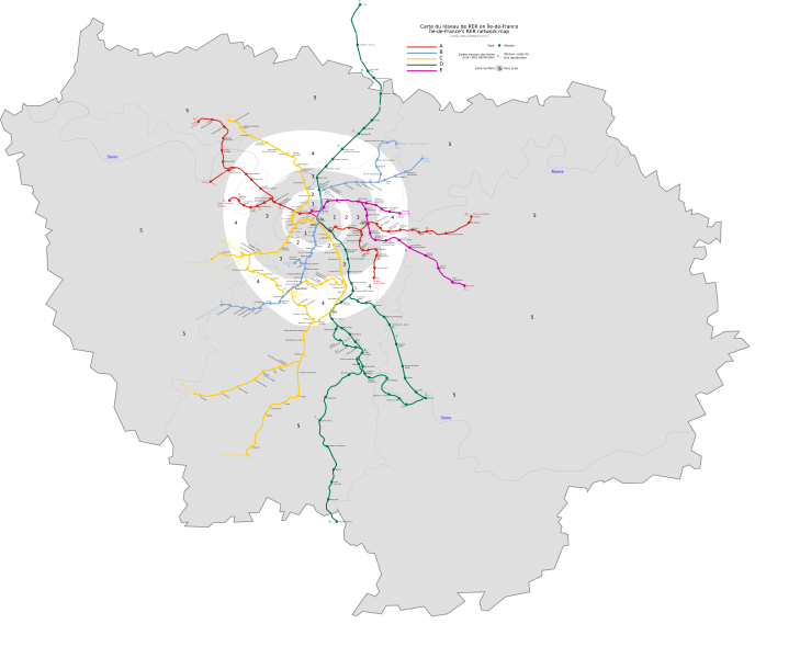
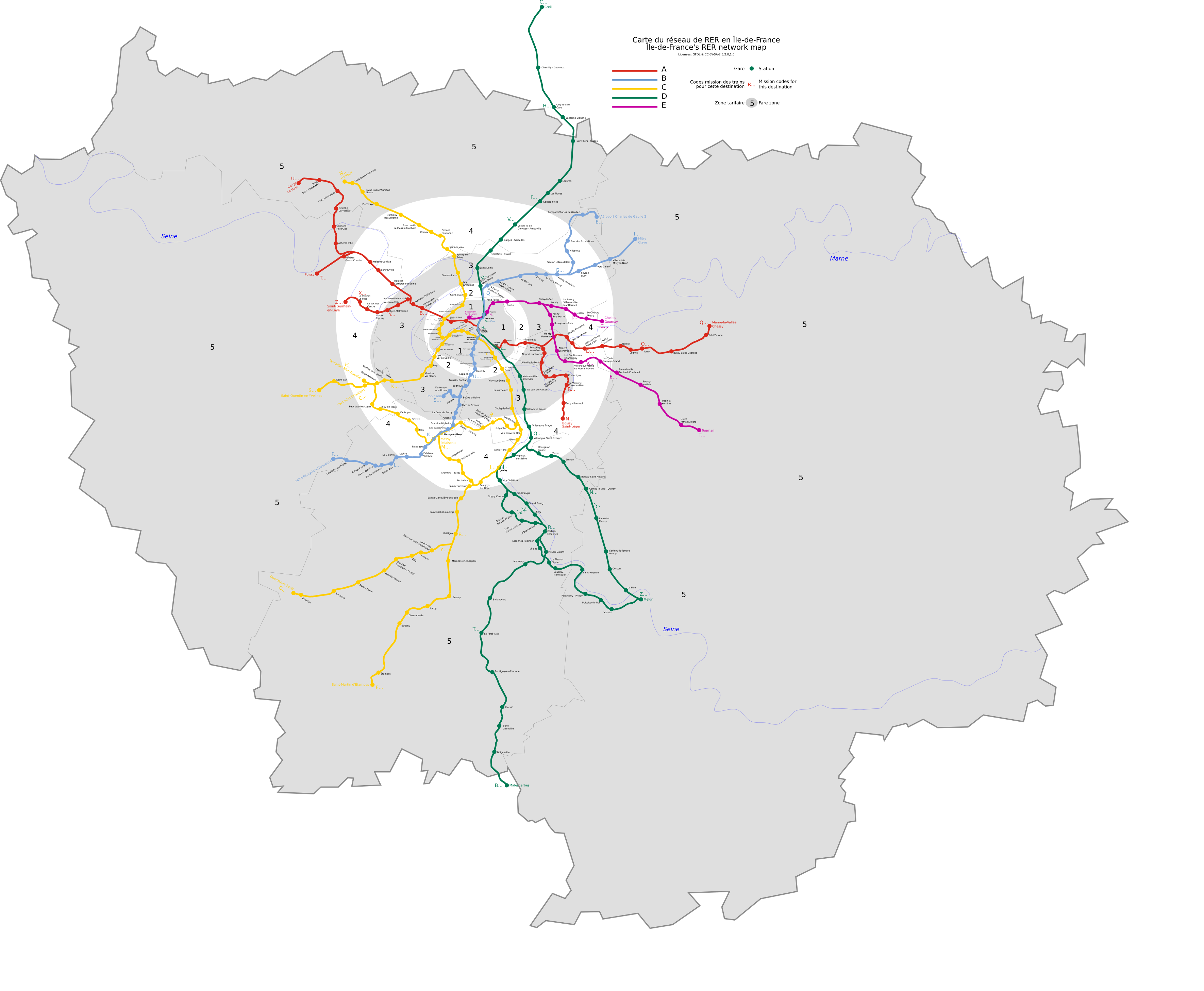
English: This is an Île de France's RER network map, in scalable vector graphics format, including fare zones, rivers and mission codes.
Français : Ceci est une carte du réseau de RER en Île de France au format vectoriel, comprenant les zones tarifaires, fleuves et codes-mission. |
||||||||
| Date | |||||||||
| Source |
Données géographiques du domaine public |
||||||||
| Author | Benoit Mortgat (User page/Page utilisateur) | ||||||||
| Permission (Reusing this file) |
I, the copyright holder of this work, hereby publish it under the following licenses:
This file is licensed under the Creative Commons Attribution-Share Alike 2.5 Generic, 2.0 Generic and 1.0 Generic license.
You may select the license of your choice. |
||||||||
| Other versions |
|


File history
Click on a date/time to view the file as it appeared at that time.
| Date/Time | Thumbnail | Dimensions | User | Comment | |
|---|---|---|---|---|---|
| current | 09:00, 14 May 2022 | | 3,540 × 2,913 (472 KB) | Lyon-St-Clair (talk | contribs) | Official colorcode lines |
| 19:40, 13 December 2015 |  | 3,540 × 2,913 (456 KB) | Gonioul (talk | contribs) | + Rosa Parks | |
| 00:04, 14 July 2011 |  | 3,540 × 2,913 (532 KB) | Gonioul (talk | contribs) | layer lock | |
| 20:37, 1 July 2011 |  | 3,540 × 2,913 (505 KB) | Gonioul (talk | contribs) | Reverted to version as of 12:08, 1 July 2011 | |
| 16:35, 1 July 2011 |  | 3,540 × 2,913 (505 KB) | Gonioul (talk | contribs) | retry | |
| 12:08, 1 July 2011 |  | 3,540 × 2,913 (505 KB) | Gonioul (talk | contribs) | Reverted to version as of 09:49, 1 July 2011 | |
| 09:50, 1 July 2011 |  | 3,540 × 2,913 (505 KB) | Gonioul (talk | contribs) | Reverted to version as of 09:43, 1 July 2011 | |
| 09:49, 1 July 2011 |  | 3,540 × 2,913 (505 KB) | Gonioul (talk | contribs) | retry | |
| 09:43, 1 July 2011 |  | 3,540 × 2,913 (505 KB) | Gonioul (talk | contribs) | Zone 6 merged into zone 5 on 1st july 2011 | |
| 15:31, 6 June 2011 |  | 3,540 × 2,913 (658 KB) | Gonioul (talk | contribs) | darker zones |
You cannot overwrite this file.
File usage on Commons
The following 24 pages use this file:
- List of stations of the Paris RER
- Maps of Paris
- Réseau Express Régional
- User:Chumwa/OgreBot/Public transport information/2015 December 11-20
- User:Chumwa/OgreBot/Public transport information/2022 May 11-20
- User:Chumwa/OgreBot/Transport Maps/2015 December 11-20
- User:Chumwa/OgreBot/Transport Maps/2022 May 11-20
- User:Hoff1980/Rail transport in France/2015 December 11-20
- User:Paris 16/Paris
- Commons:Featured picture candidates/Image:Paris RER.svg
- Commons:Featured picture candidates/Log/July 2006
- File:Paris RER.png
- File:Paris RER avant juillet 2007.svg
- File:Paris RER avant juillet 2011.svg
- File:RER A.svg
- File:RER B.svg
- File:RER C.svg
- File:RER D-2014.svg
- File:RER D.svg
- File:RER E.svg
- Category:Maps of Paris RER
- Category:Paris RER
- Category:Paris RER rolling stock
- Category:Paris RER stations
File usage on other wikis
The following other wikis use this file:
- Usage on als.wikipedia.org
- Usage on ar.wikipedia.org
- Usage on bg.wikipedia.org
- Usage on bs.wikipedia.org
- Usage on ca.wikipedia.org
- Usage on cs.wikipedia.org
- Usage on de.wikipedia.org
- Usage on en.wikipedia.org
- Usage on eo.wikipedia.org
- Usage on es.wikipedia.org
- Usage on eu.wikipedia.org
- Usage on fa.wikipedia.org
- Usage on fr.wikipedia.org
- Réseau express régional d'Île-de-France
- Histoire du métro de Paris
- Tarification des transports en commun d'Île-de-France
- Wikipédia:Atelier graphique/Images à améliorer/Archives/Avril 2008
- Zone 1 des transports en commun d'Île-de-France
- Zone 5 des transports en commun d'Île-de-France
- Zone 4 des transports en commun d'Île-de-France
- Zone 3 des transports en commun d'Île-de-France
- Zone 2 des transports en commun d'Île-de-France
- Usage on fr.wikinews.org
- Catégorie:9 décembre 2008
- Catégorie:9 décembre 2009
- Catégorie:9 décembre 2010
- Catégorie:9 décembre 2011
- Catégorie:9 décembre 2012
- Modèle:Éphéméride-9 décembre
- Évènements du 9 décembre 2012
- Catégorie:9 décembre 2013
- Évènements du 9 décembre 2013
- Catégorie:9 décembre 2014
- Évènements du 9 décembre 2014
- Catégorie:9 décembre 2015
- Évènements du 9 décembre 2015
- Catégorie:9 décembre 2016
- Évènements du 9 décembre 2016
- Catégorie:9 décembre 2017
- Évènements du 9 décembre 2017
- Catégorie:9 décembre 2018
- Évènements du 9 décembre 2018
- Catégorie:9 décembre 2019
- Évènements du 9 décembre 2019
- Catégorie:9 décembre 2020
- Catégorie:9 décembre 2021
- Catégorie:9 décembre 2022
- Catégorie:9 décembre 2023
View more global usage of this file.