File:Strategischer Bahnbau in Südbaden.png

Size of this preview: 800 × 442 pixels. Other resolutions: 320 × 177 pixels | 640 × 354 pixels | 1,024 × 566 pixels | 1,280 × 707 pixels | 2,000 × 1,105 pixels.
Original file (2,000 × 1,105 pixels, file size: 899 KB, MIME type: image/png)
Captions
Captions
Add a one-line explanation of what this file represents
| Description |
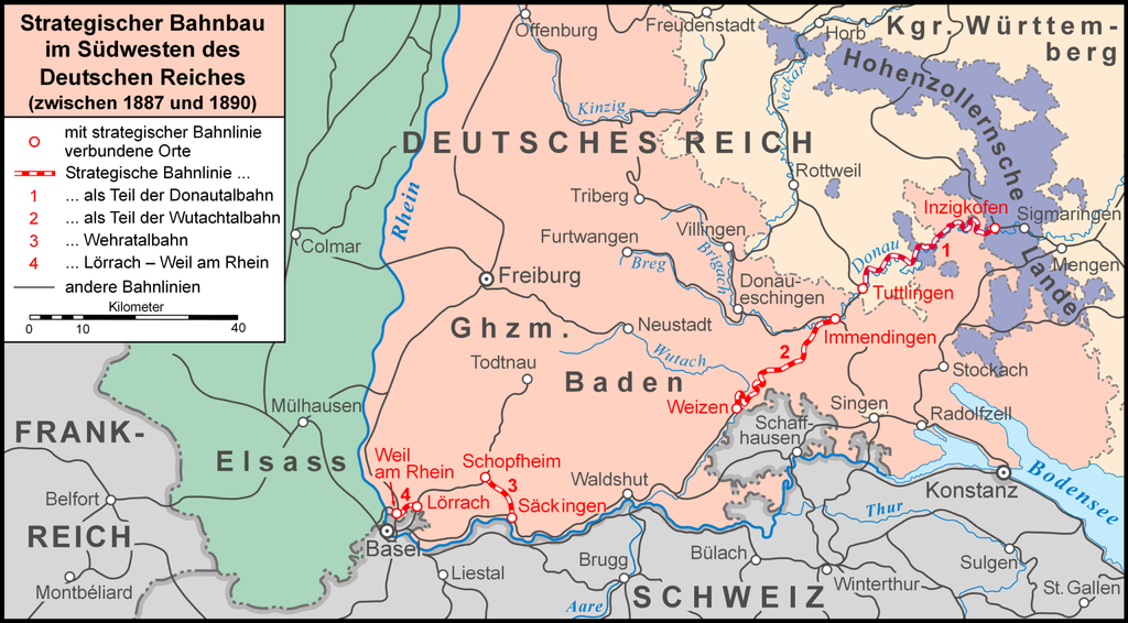
Deutsch: Strategischer Bahnbau in Südbaden und im Donautal |
| Date | |
| Source |
Own work, used: |
| Author | Lencer |
Lencer, the copyright holder of this work, hereby publishes it under the following license:
This file is licensed under the Creative Commons Attribution-Share Alike 3.0 Unported license.
Attribution: Lencer
- You are free:
- to share – to copy, distribute and transmit the work
- to remix – to adapt the work
- Under the following conditions:
- attribution – You must give appropriate credit, provide a link to the license, and indicate if changes were made. You may do so in any reasonable manner, but not in any way that suggests the licensor endorses you or your use.
- share alike – If you remix, transform, or build upon the material, you must distribute your contributions under the same or compatible license as the original.

|
This map has been made or improved in the German Kartenwerkstatt (Map Lab). You can propose maps to improve as well.
|
|
File history
Click on a date/time to view the file as it appeared at that time.
| Date/Time | Thumbnail | Dimensions | User | Comment | |
|---|---|---|---|---|---|
| current | 18:25, 28 February 2009 | | 2,000 × 1,105 (899 KB) | Lencer (talk | contribs) | Baden heller |
| 10:23, 8 February 2008 |  | 2,000 × 1,105 (866 KB) | Lencer (talk | contribs) | ||
| 19:02, 30 January 2008 |  | 2,000 × 1,104 (868 KB) | Lencer (talk | contribs) | ||
| 19:43, 28 January 2008 |  | 2,000 × 1,149 (868 KB) | Lencer (talk | contribs) | ||
| 18:16, 27 January 2008 |  | 2,000 × 1,152 (832 KB) | Lencer (talk | contribs) | ||
| 20:22, 24 January 2008 |  | 2,000 × 1,143 (430 KB) | Lencer (talk | contribs) | ||
| 17:52, 24 January 2008 |  | 2,000 × 1,259 (524 KB) | Lencer (talk | contribs) | <span style="color:#FF0000; font-size:medium; font-weight:bold; text-decoration:blink;"> Dies ist noch nicht die fertige Version, daher bitte nicht in Artikeln benutzen!<br /> That's not the final version, please don't use in articles!</span> {{Informatio |
You cannot overwrite this file.
File usage on Commons
The following page uses this file:
File usage on other wikis
The following other wikis use this file:
- Usage on als.wikipedia.org
- Usage on de.wikipedia.org
- Wutachtalbahn
- Strategische Bahn
- Wehratalbahn
- Großherzoglich Badische Staatseisenbahnen
- Benutzer:Lencer
- Benutzer:Lencer/Galerie
- Bahnstrecke Weil am Rhein–Lörrach
- Wikipedia:Exzellente Bilder/Karten und Satellitenbilder
- Geschichte Lörrachs
- Wikipedia:Kartenwerkstatt/Archiv/2008-01
- Wikipedia:Kandidaten für exzellente Bilder/Archiv2008/3
- Benutzer:Lencer/Unterseite
- Wikipedia:Kandidaten für exzellente Bilder/Archiv2009/5
- Datei:Strategischer Bahnbau in Südbaden.png
- Wikipedia:Kartenwerkstatt/Schaufenster
- Grenze zwischen Deutschland und der Schweiz
- Benutzer:GerhardSchuhmacher/Strategische Umgehungsbahn (Schweiz)
- Bahnstrecke Tuttlingen–Inzigkofen
- Strategische Bahnen zur Umgehung der Schweiz
- Usage on en.wikipedia.org
- Usage on it.wikipedia.org
- Usage on ja.wikipedia.org
- Usage on nl.wikipedia.org
- Usage on www.wikidata.org