File:Deutschland UNESCO Welterbestätten.png

Size of this preview: 623 × 600 pixels. Other resolutions: 249 × 240 pixels | 498 × 480 pixels | 798 × 768 pixels | 1,063 × 1,024 pixels | 2,000 × 1,926 pixels.
Original file (2,000 × 1,926 pixels, file size: 1.16 MB, MIME type: image/png)
Captions
Captions
Add a one-line explanation of what this file represents
Summary
edit| Description |
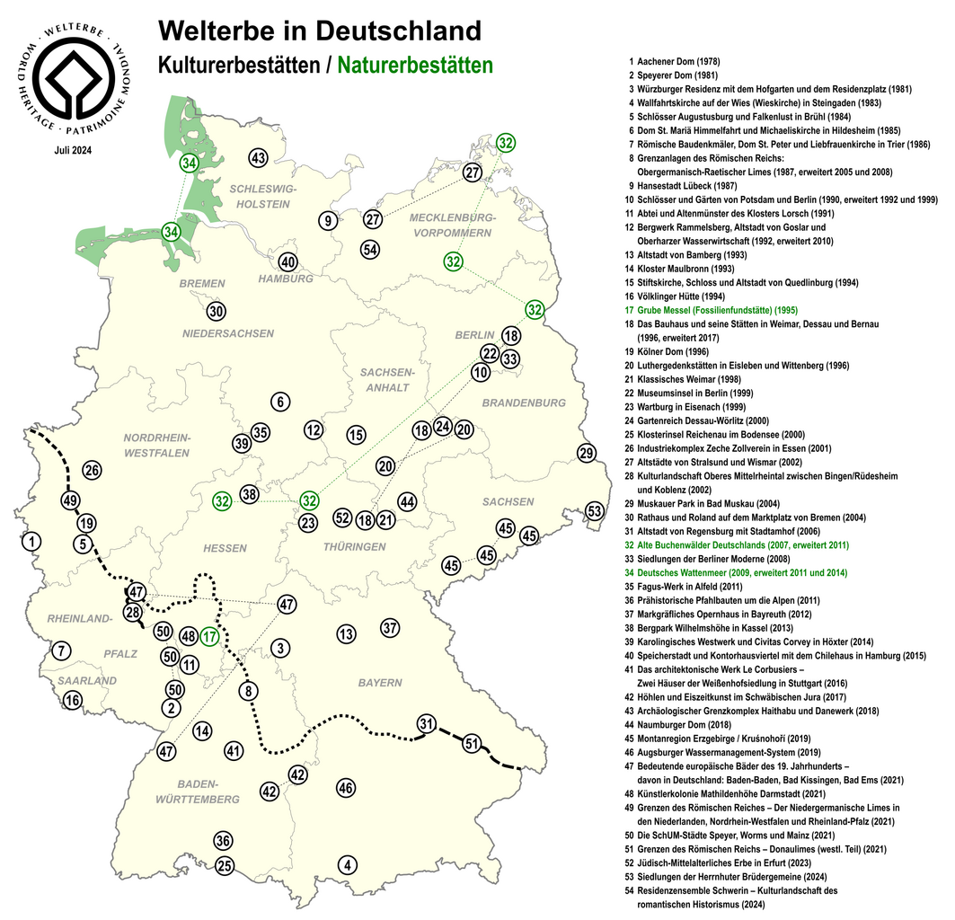
Deutsch: Karte der UNESCO Welterbestätten in Deutschland
English: Map of World Heritage Sites in Germany |
| Date | |
| Source | Own work, using Karte Bundesrepublik Deutschland.svg and Welterbe.svg (created by UNESCO; Designer: Michel Olyff, vectorized by User:Hk kng) |
| Author | Lencer |
| Other versions |
|


|
This map has been made or improved in the German Kartenwerkstatt (Map Lab). You can propose maps to improve as well.
|
Licensing
edit
I, the copyright holder of this work, hereby publish it under the following license:
This file is licensed under the Creative Commons Attribution-Share Alike 2.5 Generic license.
- You are free:
- to share – to copy, distribute and transmit the work
- to remix – to adapt the work
- Under the following conditions:
- attribution – You must give appropriate credit, provide a link to the license, and indicate if changes were made. You may do so in any reasonable manner, but not in any way that suggests the licensor endorses you or your use.
- share alike – If you remix, transform, or build upon the material, you must distribute your contributions under the same or compatible license as the original.
File history
Click on a date/time to view the file as it appeared at that time.
| Date/Time | Thumbnail | Dimensions | User | Comment | |
|---|---|---|---|---|---|
| current | 12:40, 31 July 2024 | | 2,000 × 1,926 (1.16 MB) | Lencer (talk | contribs) | add 2024, small fixes |
| 08:47, 5 December 2023 |  | 2,000 × 1,938 (1.3 MB) | Lencer (talk | contribs) | 2023 ergänzt | |
| 15:36, 2 August 2021 |  | 2,000 × 1,926 (1.17 MB) | Lencer (talk | contribs) | fix Bad Kissingen | |
| 09:15, 31 July 2021 |  | 2,000 × 1,926 (1.17 MB) | Lencer (talk | contribs) | + Donaulimes | |
| 09:43, 30 July 2021 |  | 2,000 × 1,926 (1.15 MB) | Lencer (talk | contribs) | actual, four new entrys in 2021 | |
| 10:33, 22 November 2020 |  | 2,000 × 1,793 (1.04 MB) | Lencer (talk | contribs) | fix Augsburger Wassermanagement-System | |
| 11:47, 10 July 2019 |  | 2,000 × 1,793 (1.04 MB) | Lencer (talk | contribs) | actual, two new entrys in 2019 | |
| 11:59, 2 July 2018 |  | 2,000 × 1,753 (1 MB) | Lencer (talk | contribs) | actual, two new entrys in 2018 | |
| 08:35, 26 July 2017 |  | 1,600 × 1,383 (750 KB) | Lencer (talk | contribs) | new version, completely reworked | |
| 22:59, 9 July 2017 |  | 1,609 × 1,388 (741 KB) | Joatan (talk | contribs) | Updated sites from 2017, and organised on map/numbers by chronological order of WHS list. |
You cannot overwrite this file.
File usage on Commons
The following 29 pages use this file:
- Atlas of Germany
- UNESCO world heritage sites in Bavaria
- User:Chumwa/OgreBot/Potential transport maps/2016 July 11-20
- User:Chumwa/OgreBot/Potential transport maps/2017 July 1-10
- User:Chumwa/OgreBot/Potential transport maps/2017 July 21-31
- User:Chumwa/OgreBot/Potential transport maps/2018 July 1-10
- User:Chumwa/OgreBot/Potential transport maps/2019 July 1-10
- User:Chumwa/OgreBot/Transport Maps/2015 July 1-10
- User:Chumwa/OgreBot/Transport Maps/2015 July 21-31
- User:Chumwa/OgreBot/Transport Maps/2016 July 11-20
- User:Chumwa/OgreBot/Transport Maps/2017 July 1-10
- User:Chumwa/OgreBot/Transport Maps/2017 July 21-31
- User:Chumwa/OgreBot/Transport Maps/2018 July 1-10
- User:Chumwa/OgreBot/Transport Maps/2019 July 1-10
- User:Chumwa/OgreBot/Transport Maps/2020 November 21-30
- User:Chumwa/OgreBot/Transport Maps/2021 August 1-10
- User:Chumwa/OgreBot/Transport Maps/2023 December 1-10
- User:Chumwa/OgreBot/Transport Maps/2024 July 21-31
- User:Chumwa/OgreBot/Travel and communication maps/2016 July 11-20
- User:Chumwa/OgreBot/Travel and communication maps/2017 July 1-10
- User:Chumwa/OgreBot/Travel and communication maps/2017 July 21-31
- User:Chumwa/OgreBot/Travel and communication maps/2018 July 1-10
- User:Chumwa/OgreBot/Travel and communication maps/2019 July 1-10
- User:Chumwa/OgreBot/Travel and communication maps/2020 November 21-30
- User:Chumwa/OgreBot/Travel and communication maps/2021 August 1-10
- User:Chumwa/OgreBot/Travel and communication maps/2023 December 1-10
- User:Chumwa/OgreBot/Travel and communication maps/2024 July 21-31
- File:Germany UNESCO World Heritage Sites.png
- File:World Heritage Sites in Germany map EN.png
File usage on other wikis
The following other wikis use this file:
- Usage on af.wikipedia.org
- Usage on als.wikipedia.org
- Usage on cy.wikipedia.org
- Usage on de.wikipedia.org
- Usage on es.wikipedia.org
- Usage on es.wikivoyage.org
- Usage on id.wikipedia.org
- Usage on ja.wikipedia.org
- Usage on mt.wikipedia.org
- Usage on no.wikipedia.org
- Usage on pdc.wikipedia.org
- Usage on uk.wikipedia.org