File:Köppen-geiger-hessd-2007.svg

Size of this PNG preview of this SVG file: 800 × 400 pixels. Other resolutions: 320 × 160 pixels | 640 × 320 pixels | 1,024 × 512 pixels | 1,280 × 640 pixels | 2,560 × 1,280 pixels | 900 × 450 pixels.
Original file (SVG file, nominally 900 × 450 pixels, file size: 4.53 MB)
Captions
Captions
Add a one-line explanation of what this file represents
Summary
edit| Description |
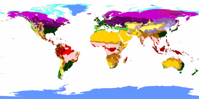
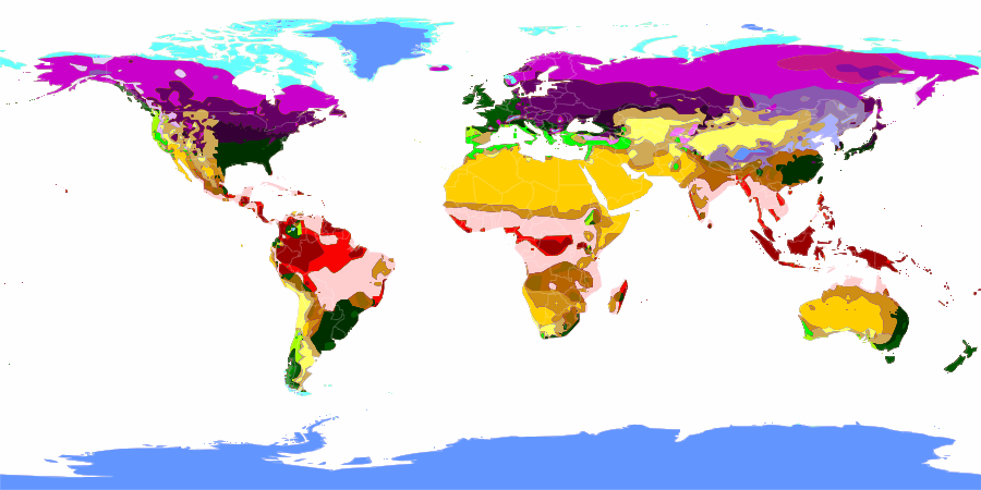
English: Peel, M. C. and Finlayson, B. L. and McMahon, T. A. (2007). "Updated world map of the Köppen-Geiger climate classification". Hydrol. Earth Syst. Sci. 11: 1633-1644. ISSN 1027-5606.
Deutsch: Diese Karte stellt die Klimaklassen der Erde nach Köppen-Geiger dar.
ANMERKUNG vom 7. Januar 2022: Diese Karte ist in etlichen Bereichen fehlerhaft und sollte nicht mehr verwendet werden. Alternativ bietet sich diese Köppen-Geiger-Karte an. Fährtenleser–- Af Am Aw BWh BWk BSh BSk Csa Csb Cwa Cwb Cwc Cfa Cfb Cfc Dsa Dsb Dsc Dsd Dwa Dwb Dwc Dwd Dfa Dfb Dfc Dfd ET EF |
||
| Date | |||
| Source | Selbst erstellt auf Basis dieser Geodaten. | ||
| Author | LordToran | ||
| Permission (Reusing this file) |
|||
| Other versions |
|
||
| SVG development |
.svg)
Licensing
edit
This file is licensed under the Creative Commons Attribution-Share Alike 3.0 Unported license.
- You are free:
- to share – to copy, distribute and transmit the work
- to remix – to adapt the work
- Under the following conditions:
- attribution – You must give appropriate credit, provide a link to the license, and indicate if changes were made. You may do so in any reasonable manner, but not in any way that suggests the licensor endorses you or your use.
- share alike – If you remix, transform, or build upon the material, you must distribute your contributions under the same or compatible license as the original.
File history
Click on a date/time to view the file as it appeared at that time.
| Date/Time | Thumbnail | Dimensions | User | Comment | |
|---|---|---|---|---|---|
| current | 14:15, 15 October 2007 | | 900 × 450 (4.53 MB) | Lortordermur (talk | contribs) | == Beschreibung == {{Information |Description=Diese Karte stellt die Klimazonen der Erde nach Köppen-Geiger dar. {{legend|#990101|Af}}{{legend|#f90303|Am}}{{legend|#ffcfcf|Aw}} {{legend|#ffcf00|BWh}}{{legend|#ffff65|BWk}}{{legend|#cf8e14|BSh}}{{legend| |
| 22:06, 14 October 2007 |  | 860 × 432 (3.79 MB) | Lortordermur (talk | contribs) | Reverted to version as of 21:24, 14 October 2007 | |
| 22:05, 14 October 2007 |  | 3,600 × 1,800 (4.55 MB) | Lortordermur (talk | contribs) | == Beschreibung == {{Information |Description=Diese Karte stellt die Klimazonen der Erde nach Köppen-Geiger dar. {{legend|#990101|Af}}{{legend|#f90303|Am}}{{legend|#ffcfcf|Aw}} {{legend|#ffcf00|BWh}}{{legend|#ffff65|BWk}}{{legend|#cf8e14|BSh}}{{legend| | |
| 21:24, 14 October 2007 |  | 860 × 432 (3.79 MB) | Lortordermur (talk | contribs) | Reverted to version as of 22:28, 26 June 2007 | |
| 21:23, 14 October 2007 |  | 3,600 × 1,800 (16.85 MB) | Lortordermur (talk | contribs) | == Beschreibung == {{Information |Description=Diese Karte stellt die Klimazonen der Erde nach Köppen-Geiger dar. {{legend|#990101|Af}}{{legend|#f90303|Am}}{{legend|#ffcfcf|Aw}} {{legend|#ffcf00|BWh}}{{legend|#ffff65|BWk}}{{legend|#cf8e14|BSh}}{{legend| | |
| 22:28, 26 June 2007 |  | 860 × 432 (3.79 MB) | Lortordermur (talk | contribs) | == Beschreibung == {{Information |Description=Diese Karte stellt die Klimazonen der Erde nach Köppen-Geiger dar. {{legend|#990101|Af}}{{legend|#f90303|Am}}{{legend|#ffcfcf|Aw}} {{legend|#ffcf00|BWh}}{{legend|#ffff65|BWk}}{{legend|#cf8e14|BSh}}{{legend| | |
| 21:33, 26 June 2007 |  | 3,442 × 1,730 (14.81 MB) | Lortordermur (talk | contribs) | == Beschreibung == {{Information |Description=Diese Karte stellt die Klimazonen der Erde nach Köppen-Geiger dar. {{legend|#990101|Af}}{{legend|#f90303|Am}}{{legend|#ffcfcf|Aw}} {{legend|#ffcf00|BWh}}{{legend|#ffff65|BWk}}{{legend|#cf8e14|BSh}}{{legend| |
You cannot overwrite this file.
File usage on Commons
The following page uses this file:
File usage on other wikis
The following other wikis use this file:
- Usage on als.wikipedia.org
- Usage on crh.wikipedia.org
- Usage on da.wikipedia.org
- Usage on da.wikibooks.org
- Usage on hi.wikipedia.org
- Usage on ja.wikipedia.org
- Usage on nds.wikipedia.org
- Usage on uk.wikipedia.org