File:Kilimanjaro and Arusha National Parks map-fr.svg

Size of this PNG preview of this SVG file: 800 × 578 pixels. Other resolutions: 320 × 231 pixels | 640 × 463 pixels | 1,024 × 740 pixels | 1,280 × 925 pixels | 2,560 × 1,851 pixels | 2,242 × 1,621 pixels.
Original file (SVG file, nominally 2,242 × 1,621 pixels, file size: 1.6 MB)
Captions
Captions
Add a one-line explanation of what this file represents
Summary
edit| Description |
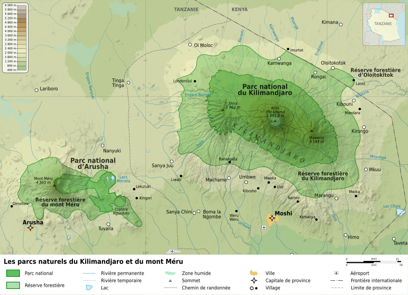
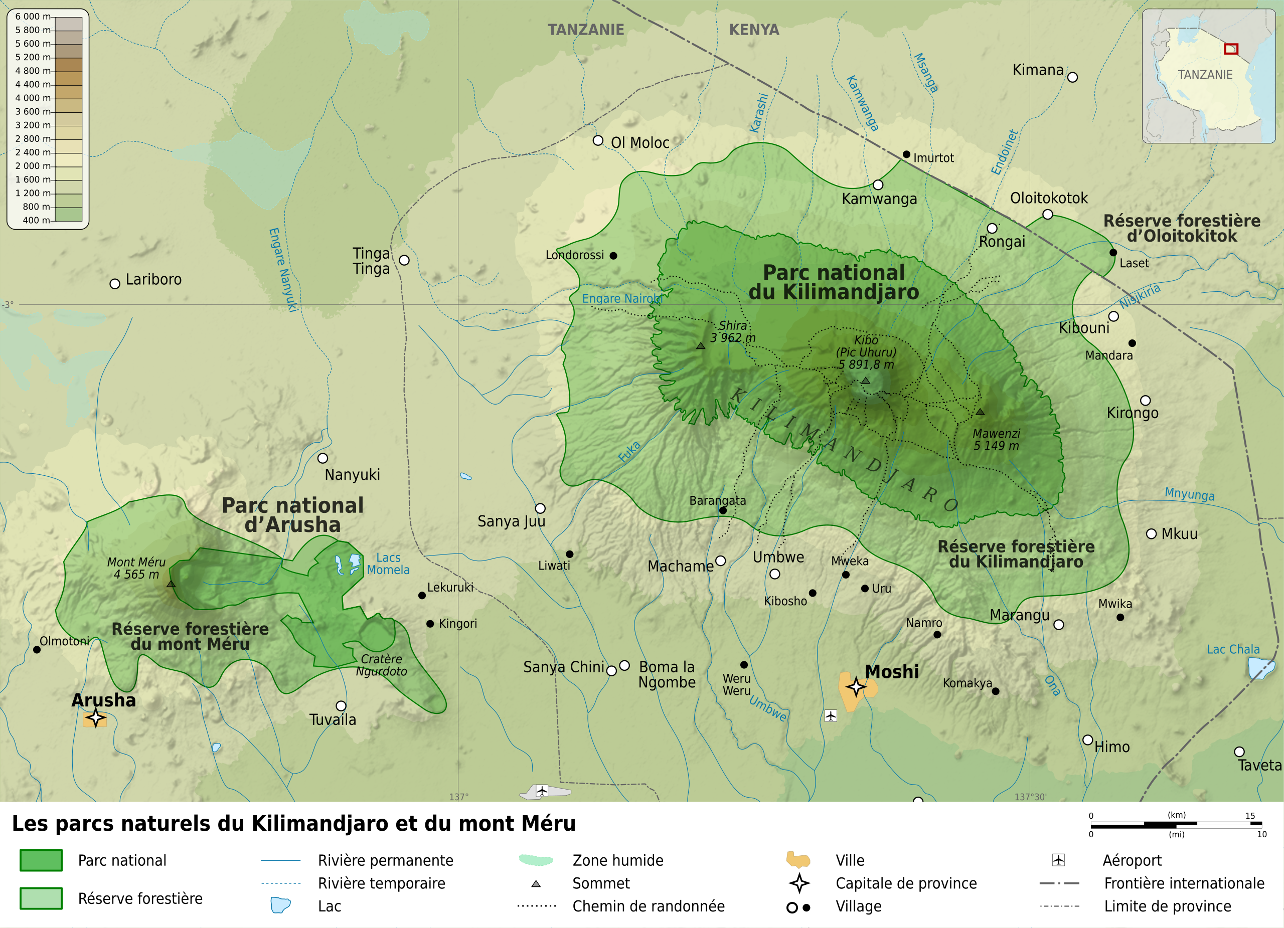
Français : Carte des parcs nationaux et réserves forestières du Kilimandjaro et du Mont Méru, Tanzanie. |
||
| Date | (UTC) | ||
| Source |
|
||
| Author |
|
||
| Other versions |
Derivative works of this file: | ||
| Attribution (required by the license) | © Sémhur / Wikimedia Commons / | ||
| SVG | W3C-validity not checked.
|
||
| Graphic Lab |

![[1]](http://www.lave-volcans.com/images/volcans/meru/fiches_meru_carte.jpg)
| Object location | | View this and other nearby images on: OpenStreetMap |
|---|
Licensing
edit
I, the copyright holder of this work, hereby publish it under the following licenses:
| Copyleft: This work of art is free; you can redistribute it and/or modify it according to terms of the Free Art License. You will find a specimen of this license on the Copyleft Attitude site as well as on other sites. |
This file is licensed under the Creative Commons Attribution-Share Alike 4.0 International, 3.0 Unported, 2.5 Generic, 2.0 Generic and 1.0 Generic license.
- You are free:
- to share – to copy, distribute and transmit the work
- to remix – to adapt the work
- Under the following conditions:
- attribution – You must give appropriate credit, provide a link to the license, and indicate if changes were made. You may do so in any reasonable manner, but not in any way that suggests the licensor endorses you or your use.
- share alike – If you remix, transform, or build upon the material, you must distribute your contributions under the same or compatible license as the original.
You may select the license of your choice.
Original upload log
edit
This image is a derivative work of the following images:
- File:Mount_Kilimanjaro_and_Mount_Meru_map-fr.svg licensed with Cc-by-sa-3.0,2.5,2.0,1.0, GFDL
- 2009-04-21T13:12:39Z Sémhur 3364x2832 (1764745 Bytes) Better with legend.
- 2009-04-21T11:50:20Z Sémhur 3363x2431 (1752381 Bytes) == Description == {{Information |Description={{en|1=Map of [[:en:Mount Kilimanjaro|Mount Kilimanjaro]] and [[:en:Mount Meru|Mount Meru]], Tanzania.}} {{fr|1=Carte du [[:fr:Kilimandjaro|Kilimandjaro]] et du [[:fr:Mont Méru|Mo
Uploaded with derivativeFX
File history
Click on a date/time to view the file as it appeared at that time.
| Date/Time | Thumbnail | Dimensions | User | Comment | |
|---|---|---|---|---|---|
| current | 14:58, 11 May 2009 | | 2,242 × 1,621 (1.6 MB) | Sémhur (talk | contribs) | Smaller size |
| 20:05, 30 April 2009 |  | 3,363 × 2,431 (1.6 MB) | Sémhur (talk | contribs) | Misspelling. | |
| 21:41, 29 April 2009 |  | 3,363 × 2,431 (1.6 MB) | Sémhur (talk | contribs) | {{Information |Description={{en|1=Map of Mount Kilimanjaro and Mount Meru, Tanzania.}} {{fr|1=Carte du Kilimandjaro et du Mont Méru, Tanzanie.}} {{es|1=Mapa del [[:es:Ki |
You cannot overwrite this file.
File usage on Commons
The following 2 pages use this file:
File usage on other wikis
The following other wikis use this file:
- Usage on als.wikipedia.org
- Usage on avk.wikipedia.org
- Usage on bg.wikipedia.org
- Usage on de.wikipedia.org
- Usage on fr.wikipedia.org
- Usage on it.wikipedia.org