File:Zones A and B in the occupied palestinian territories.svg

Size of this PNG preview of this SVG file: 520 × 599 pixels. Other resolutions: 208 × 240 pixels | 417 × 480 pixels | 667 × 768 pixels | 889 × 1,024 pixels | 1,778 × 2,048 pixels | 639 × 736 pixels.
Original file (SVG file, nominally 639 × 736 pixels, file size: 903 KB)
Captions
Captions
Add a one-line explanation of what this file represents
Summary
edit
| Description |
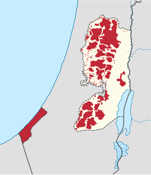
Deutsch: Lage der Zonen A&B in Palästina.
English: Location of zones A&B in Palestine
العربية: خريطة للسلطة الفلسطينية، حيث توضح المنباللون الأحمر المناطق الخاضعة لسيطرة السلطة الفلسطينية وهي المنطقة أ والمنطقة ب، حسب اتفاقية أوسلو الثانية الت
. |
| Date | |
| Source |
Own work This W3C-unspecified vector image was created with Adobe Illustrator. This SVG file was uploaded with Commonist. This vector image includes elements that have been taken or adapted from this file: |
| Author |
TUBS |
| Other versions |
|
Licensing
edit
I, the copyright holder of this work, hereby publish it under the following licenses:

|
Permission is granted to copy, distribute and/or modify this document under the terms of the GNU Free Documentation License, Version 1.2 or any later version published by the Free Software Foundation; with no Invariant Sections, no Front-Cover Texts, and no Back-Cover Texts. A copy of the license is included in the section entitled GNU Free Documentation License. |
This file is licensed under the Creative Commons Attribution-Share Alike 3.0 Unported license.
- You are free:
- to share – to copy, distribute and transmit the work
- to remix – to adapt the work
- Under the following conditions:
- attribution – You must give appropriate credit, provide a link to the license, and indicate if changes were made. You may do so in any reasonable manner, but not in any way that suggests the licensor endorses you or your use.
- share alike – If you remix, transform, or build upon the material, you must distribute your contributions under the same or compatible license as the original.
You may select the license of your choice.

|
I'd greatly appreciate, that you attribute this media file to Wikimedia Commons, if used outside Wikipedia or Commons. For use in publications such as books, newspapers, blogs, websites, please insert here the following line:
|
File history
Click on a date/time to view the file as it appeared at that time.
| Date/Time | Thumbnail | Dimensions | User | Comment | |
|---|---|---|---|---|---|
| current | 11:08, 21 June 2021 | | 639 × 736 (903 KB) | TUBS (talk | contribs) | Reverted to version as of 11:32, 8 December 2017 (UTC) keep image size and its pixel ration. otherwise imagemaps are broken thx |
| 08:52, 21 June 2021 |  | 512 × 663 (395 KB) | ויקי4800 (talk | contribs) | תיקון | |
| 11:32, 8 December 2017 |  | 639 × 736 (903 KB) | TUBS (talk | contribs) | Reverted to version as of 12:57, 18 November 2011 (UTC). not according to color scheme. keep the size - don't break imagemaps | |
| 16:51, 7 December 2017 |  | 521 × 569 (282 KB) | Dank Chicken (talk | contribs) | New colour for Gaza strip. Also zoomed in the map | |
| 12:57, 18 November 2011 |  | 639 × 736 (903 KB) | TUBS (talk | contribs) | corr | |
| 11:42, 17 November 2011 |  | 639 × 736 (899 KB) | TUBS (talk | contribs) | == {{int:filedesc}} == {{Information |Description={{de|Lage des Distrikts XY (siehe Dateiname) in Palästina.}} {{en|Location of district XY (see filename) in Palestine}} |Source={{own}}{{Adobe Illustrator}}{{Commonist |
You cannot overwrite this file.
File usage on Commons
The following 40 pages use this file:
- User:Geagea/Israel/2017 December 7
- User:Geagea/Israel/2017 December 8
- File:Map of Palestine for talk page.png
- File:Palestine, administrative divisions (Zones A+B) - Nmbrs - colored.svg
- File:Palestine, administrative divisions (Zones A+B) - Nmbrs - colored (Zone C hatched).svg
- File:Palestine, administrative divisions (Zones A+B) - Nmbrs - monochrome.svg
- File:Palestine, administrative divisions (Zones A+B) - Nmbrs - monochrome (Zone C hatched).svg
- File:Palestine, administrative divisions (Zones A+B) - de - colored.svg
- File:Palestine, administrative divisions (Zones A+B) - de - colored (Zone C hatched).svg
- File:Palestine, administrative divisions (Zones A+B) - de - monochrome.svg
- File:Palestine, administrative divisions (Zones A+B) - de - monochrome (Zone C hatched).svg
- File:Palestine (Zones A+B) (+all claims), administrative divisions - Nmbrs - colored.svg
- File:Palestine (Zones A+B) (+all claims), administrative divisions - Nmbrs - colored (Zone C hatched).svg
- File:Palestine (Zones A+B) (+all claims), administrative divisions - Nmbrs - monochrome.svg
- File:Palestine (Zones A+B) (+all claims), administrative divisions - Nmbrs - monochrome (Zone C hatched).svg
- File:Palestine (Zones A+B) (+all claims), administrative divisions - de - colored.svg
- File:Palestine (Zones A+B) (+all claims), administrative divisions - de - colored (Zone C hatched).svg
- File:Palestine (Zones A+B) (+all claims), administrative divisions - de - monochrome.svg
- File:Palestine (Zones A+B) (+all claims), administrative divisions - de - monochrome (Zone C hatched).svg
- File:Palestine (Zones A+B) (-claimed), administrative divisions - Nmbrs - colored.svg
- File:Palestine (Zones A+B) (-claimed), administrative divisions - Nmbrs - colored (Zone C hatched).svg
- File:Palestine (Zones A+B) (-claimed), administrative divisions - Nmbrs - monochrome.svg
- File:Palestine (Zones A+B) (-claimed), administrative divisions - Nmbrs - monochrome (Zone C hatched).svg
- File:Palestine (Zones A+B) (-claimed), administrative divisions - de - colored.svg
- File:Palestine (Zones A+B) (-claimed), administrative divisions - de - colored (Zone C hatched).svg
- File:Palestine (Zones A+B) (-claimed), administrative divisions - de - monochrome.svg
- File:Palestine (Zones A+B) (-claimed), administrative divisions - de - monochrome (Zone C hatched).svg
- File:Palestine (Zones A+B) (claims hatched), administrative divisions - Nmbrs - colored.svg
- File:Palestine (Zones A+B) (claims hatched), administrative divisions - Nmbrs - colored (Zone C hatched).svg
- File:Palestine (Zones A+B) (claims hatched), administrative divisions - Nmbrs - monochrome.svg
- File:Palestine (Zones A+B) (claims hatched), administrative divisions - Nmbrs - monochrome (Zone C hatched).svg
- File:Palestine (Zones A+B) (claims hatched), administrative divisions - de - colored.svg
- File:Palestine (Zones A+B) (claims hatched), administrative divisions - de - colored (Zone C hatched).svg
- File:Palestine (Zones A+B) (claims hatched), administrative divisions - de - monochrome.svg
- File:Palestine (Zones A+B) (claims hatched), administrative divisions - de - monochrome (Zone C hatched).svg
- File:Palestinian controlled areas (zones A and B) in Israel and in its region.svg
- File:Palestinian controlled areas (zones A and B) in its region.svg
- File:Palestinian controlled areas (zones A and B, C hatched) in Israel and in its region.svg
- File:Palestinian controlled areas (zones A and B, C hatched) in its region.svg
- File:Zones A and B in the occupied palestinian territories e.svg (file redirect)
_-_Nmbrs_-_colored.svg)
_-_Nmbrs_-_colored_(Zone_C_hatched).svg)
_-_Nmbrs_-_monochrome.svg)
_-_Nmbrs_-_monochrome_(Zone_C_hatched).svg)
_-_de_-_colored.svg)
_-_de_-_colored_(Zone_C_hatched).svg)
_-_de_-_monochrome.svg)
_-_de_-_monochrome_(Zone_C_hatched).svg)
_(%2Ball_claims),_administrative_divisions_-_Nmbrs_-_colored.svg)
_(%2Ball_claims),_administrative_divisions_-_Nmbrs_-_colored_(Zone_C_hatched).svg)
_(%2Ball_claims),_administrative_divisions_-_Nmbrs_-_monochrome.svg)
_(%2Ball_claims),_administrative_divisions_-_Nmbrs_-_monochrome_(Zone_C_hatched).svg)
_(%2Ball_claims),_administrative_divisions_-_de_-_colored.svg)
_(%2Ball_claims),_administrative_divisions_-_de_-_colored_(Zone_C_hatched).svg)
_(%2Ball_claims),_administrative_divisions_-_de_-_monochrome.svg)
_(%2Ball_claims),_administrative_divisions_-_de_-_monochrome_(Zone_C_hatched).svg)
_(-claimed),_administrative_divisions_-_Nmbrs_-_colored.svg)
_(-claimed),_administrative_divisions_-_Nmbrs_-_colored_(Zone_C_hatched).svg)
_(-claimed),_administrative_divisions_-_Nmbrs_-_monochrome.svg)
_(-claimed),_administrative_divisions_-_Nmbrs_-_monochrome_(Zone_C_hatched).svg)
_(-claimed),_administrative_divisions_-_de_-_colored.svg)
_(-claimed),_administrative_divisions_-_de_-_colored_(Zone_C_hatched).svg)
_(-claimed),_administrative_divisions_-_de_-_monochrome.svg)
_(-claimed),_administrative_divisions_-_de_-_monochrome_(Zone_C_hatched).svg)
_(claims_hatched),_administrative_divisions_-_Nmbrs_-_colored.svg)
_(claims_hatched),_administrative_divisions_-_Nmbrs_-_colored_(Zone_C_hatched).svg)
_(claims_hatched),_administrative_divisions_-_Nmbrs_-_monochrome.svg)
_(claims_hatched),_administrative_divisions_-_Nmbrs_-_monochrome_(Zone_C_hatched).svg)
_(claims_hatched),_administrative_divisions_-_de_-_colored.svg)
_(claims_hatched),_administrative_divisions_-_de_-_colored_(Zone_C_hatched).svg)
_(claims_hatched),_administrative_divisions_-_de_-_monochrome.svg)
_(claims_hatched),_administrative_divisions_-_de_-_monochrome_(Zone_C_hatched).svg)
_in_Israel_and_in_its_region.svg)
_in_its_region.svg)
_in_Israel_and_in_its_region.svg)
_in_its_region.svg.html)
File usage on other wikis
The following other wikis use this file:
- Usage on als.wikipedia.org
- Usage on ar.wikipedia.org
- Usage on arz.wikipedia.org
- Usage on ast.wikipedia.org
- Usage on bg.wikipedia.org
- Usage on bn.wikipedia.org
- Usage on br.wikipedia.org
- Usage on bxr.wikipedia.org
- Usage on ca.wikipedia.org
- Usage on ckb.wikipedia.org
- Usage on cr.wikipedia.org
- Usage on cs.wikipedia.org
- Usage on da.wikipedia.org
- Usage on de.wikipedia.org
- Usage on en.wikipedia.org
- Usage on en.wikiquote.org
- Usage on eo.wikipedia.org
- Usage on es.wikipedia.org
- Usage on et.wikipedia.org
- Usage on eu.wikipedia.org
- Usage on fa.wikipedia.org
- Usage on fi.wikipedia.org
- Usage on fr.wikipedia.org
- Usage on fy.wikipedia.org
- Usage on gl.wikipedia.org
- Usage on hr.wikipedia.org
- Usage on hsb.wikipedia.org
- Usage on id.wikipedia.org
- Usage on it.wikipedia.org
- Usage on ka.wikipedia.org
- Usage on km.wikipedia.org
- Usage on ko.wikipedia.org
- Usage on lij.wikipedia.org
- Usage on li.wikipedia.org
View more global usage of this file.