File:Mayamap.png

Size of this preview: 800 × 588 pixels. Other resolutions: 320 × 235 pixels | 640 × 470 pixels | 1,024 × 752 pixels | 1,074 × 789 pixels.
Original file (1,074 × 789 pixels, file size: 1,010 KB, MIME type: image/png)
Captions
Captions
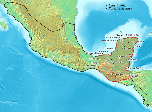
Map of mesoamerica with the Mayans highlighted in red

|
This map image could be re-created using vector graphics as an SVG file. This has several advantages; see Commons:Media for cleanup for more information. If an SVG form of this image is available, please upload it and afterwards replace this template with
{{vector version available|new image name}}.
It is recommended to name the SVG file “Mayamap.svg”—then the template Vector version available (or Vva) does not need the new image name parameter. |
Summary
edit
| Description |
English: Map showing the extent of the Maya civilization (red), compared to all other Mesoamerica cultures (black).
|
| Date | |
| Source |
|
| Author | Kmusser |
| Other versions |
This file was derived from: Mayas.png |
Licensing
edit
I, the copyright holder of this work, hereby publish it under the following license:

|
Permission is granted to copy, distribute and/or modify this document under the terms of the GNU Free Documentation License, Version 1.2 or any later version published by the Free Software Foundation; with no Invariant Sections, no Front-Cover Texts, and no Back-Cover Texts. A copy of the license is included in the section entitled GNU Free Documentation License. |
| This file is licensed under the Creative Commons Attribution-Share Alike 3.0 Unported license. | ||
| ||
| This licensing tag was added to this file as part of the GFDL licensing update. |
File history
Click on a date/time to view the file as it appeared at that time.
| Date/Time | Thumbnail | Dimensions | User | Comment | |
|---|---|---|---|---|---|
| current | 20:27, 20 July 2006 | | 1,074 × 789 (1,010 KB) | Kmusser (talk | contribs) | Map showing the extent of the Maya civilization, adopted from Mayas.png. |
You cannot overwrite this file.
File usage on Commons
The following 7 pages use this file:
File usage on other wikis
The following other wikis use this file:
- Usage on af.wikipedia.org
- Usage on ar.wikipedia.org
- Usage on azb.wikipedia.org
- Usage on az.wikipedia.org
- Usage on ba.wikipedia.org
- Usage on be-tarask.wikipedia.org
- Usage on bg.wikipedia.org
- Usage on bo.wikipedia.org
- Usage on br.wikipedia.org
- Usage on ca.wikipedia.org
- Usage on cs.wikipedia.org
- Usage on cy.wikipedia.org
- Usage on da.wikipedia.org
- Usage on diq.wikipedia.org
- Usage on el.wikipedia.org
- Usage on en.wikipedia.org
- Belize
- Tikal
- Maya peoples
- List of conflicts in North America
- User:Kmusser/Images
- List of Maya sites
- File talk:Mayamap.png
- Maya civilization
- User talk:Jayantanth/Archive 1
- Pre-Columbian Belize
- History of Belize
- Maya city
- User:Wiki Raja/Gallery
- List of conflicts in Mexico
- Wikipedia:Wikipedia Signpost/2015-08-05/Featured content
- Wikipedia:Wikipedia Signpost/Single/2015-08-05
- Talk:Maya civilization/WTF
- Portal:Civilizations
- User:SomeGuyWhoRandomlyEdits/List of conflicts in Mexico
- Usage on en.wikibooks.org
- Usage on es.wikipedia.org
- Usage on et.wikipedia.org
- Usage on eu.wikipedia.org
- Usage on fa.wikipedia.org
- Usage on fi.wikipedia.org
- Usage on fr.wikipedia.org
View more global usage of this file.